

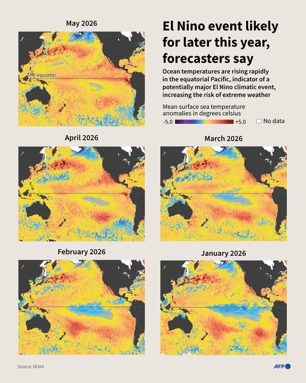
The World Meteorological Organisation has confirmed that warm waters in the tropical Pacific Ocean are fuelling the development of a significant 'El Niño' planet-warming event, which will increase global temperatures and drive more extreme weather and rainfall events in the months ahead.
It said its forecasting models are 80% certain that above-average temperatures are likely to be recorded almost everywhere from June to August.
There is also a 90% likelihood that the warming impact of the El Niño phenomenon will continue and intensify out to November and beyond.
UN Secretary General António Guterres said the world must treat the message from the World Meteorological Organisation (WMO) as the urgent climate warning it is and warned that El Niño conditions will pour fuel on the fire of a warming world.
He said the impacts will hit even harder, travel even farther, and cross borders with devastating speed.
Read more: Scientists fear rising temperatures may become new normal
Watch: El Niño arriving with 90% certainty, says UN's Guterres
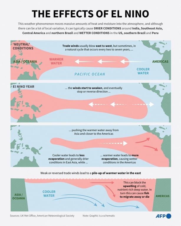
The ocean warming events that drive the El Niño process are one of the most powerful naturally occurring climate patterns on Earth.
It is characterised by a warming of ocean surface temperatures in the central and eastern Equatorial Pacific.
It typically occurs every two to seven years and lasts around nine to 12 months.
It generally begins developing between March and June and reaches its peak intensity between November and February, with impacts on global temperatures typically being most pronounced in the second year after development.
There is no evidence that climate change increases the frequency or intensity of El Niño events.
However, the additional background atmospheric heating caused by climate change can amplify the impacts associated with an El Niño.
Conditions oscillate between El Niño and its opposite La Niña, with neutral conditions in between.
Meteorologists are predicting that although global temperatures will be elevated this year, next year 2027, is already shaping up to be the hottest year on record.
Secretary General of the WMO Andrea Celeste Saulo said the world needs to prepare for a potentially strong El Niño event, which will exacerbate drought and heavy rainfall and increase the risk of heatwaves both on land and in the ocean.
The most recent El Niño, in 2023 and 2024, was one of the five strongest on record and it played a role in the record global temperatures in 2024.
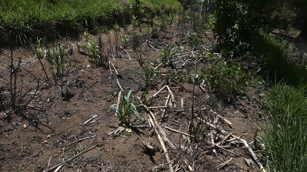
Typical impacts of El Niño events include increased rainfall in parts of southern South America, the southern United States, parts of the Horn of Africa and central Asia, and drier conditions over Central America, northern South America, the Caribbean, Australia, Indonesia, and parts of southern Asia.
El Niño's warm water also tends to fuel hurricanes in the central and eastern Pacific Ocean.
However, it usually hinders hurricane formation in the Atlantic Basin, where a quieter storm season can impact Ireland.
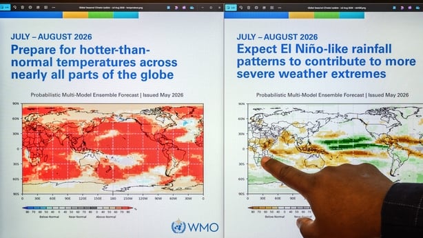
The forecasted maps of global warming and precipitation published by the WMO alongside its El Niño update suggest that Ireland will experience less rainfall due to the El Niño.
Ireland was among many countries in Europe which saw record-breaking temperatures last month.
At the same time, the WMO indications suggest that while temperatures in Ireland are likely to be above normal, the country is likely to escape the main warming impacts caused by the coming El Niño event.
Regional climate centres are predicting "below-normal" rainfall during the critical June-September rainy season in the northern Greater Horn of Africa; below-average monsoon rainfall in south Asia; and drier and warmer summer conditions in central America.
During the northern hemisphere summer, warm waters associated with El Niño can fuel hurricanes in the central and eastern Pacific, while hindering their development in the Atlantic Ocean.
The WMO hopes advance warning will guide preparedness, especially in climate-sensitive sectors like agriculture, water management, energy and health.
Additional reporting AFP