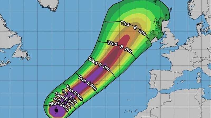

Met Éireann has said it is seriously concerned about a very powerful hurricane in the central Atlantic that is tracking northeastwards towards Ireland.
With hurricane force winds stretching one hundred and fifty kilometres from the eye at its centre and tropical force winds stretching out for 405 kilometres, Lorenzo is massive.
It is currently situated in the Central Atlantic, at about 29 degrees latitude, travelling at about 20 kilometres per hour towards the Azores.
Thereafter it is expected to speed up as it travels over cooler waters and heads straight the direction of Ireland.
Some forecasting models used by meteorologists are predicting Lorenzo will pass directly to the West of Ireland while others suggest it will turn right and move directly in over the country by late Thursday and early Friday.
We need your consent to load this rte-player contentWe use rte-player to manage extra content that can set cookies on your device and collect data about your activity. Please review their details and accept them to load the content.Manage Preferences
However, Met Éireann said there is far too much uncertainty about the trajectory of this storm to be sure about its likely impact on Ireland.
It is checking constantly with meteorologists in the UK and Europe and updating its forecasting with new information.
Two years ago when Storm Ophelia - which had been downgraded from a hurricane - hit Ireland it brought wind speeds of 156 kilometres per hour, caused major power outages, lifted roofs, felled countless trees, and caused significant coastal flooding. Tragically three lives were lost. All schools and many businesses were closed for the day while the country weathered the storm.
Nobody in forecasting circles is saying yet that Hurricane Lorenzo will be as bad as Ophelia was two years ago. But nobody is saying that it will not be.
There is simply far too much uncertainty to know.
What we do know is that very significant storm conditions will affect the country later this week with warnings of coastal swells and rough seas from Wednesday onwards.
Head of forecasting at Met Éireann, Evelyn Cusack, said they will not be issuing any weather warnings in relation to the storm until at least Wednesday.
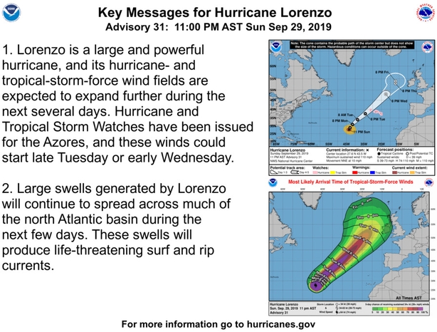
According to the US National Hurricane Center, Lorenzo has strengthened to a category 5 hurricane, with maximum sustained winds of 250km/h.
The NHC said that it was the strongest hurricane on record this far north and east in the Atlantic basin.
The storm is expected to lose its major status as it moves northwards across cooler waters.
RTÉ Brainstorm: Why we can expect to see more hurricanes coming our way
We need your consent to load this rte-player contentWe use rte-player to manage extra content that can set cookies on your device and collect data about your activity. Please review their details and accept them to load the content.Manage Preferences


