
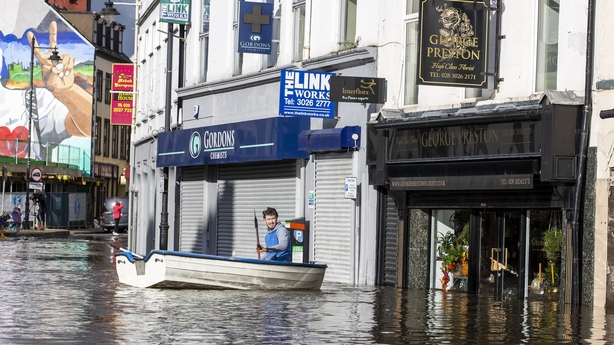
The city of Newry is preparing for a challenging night ahead, as it struggles to deal with the impact of serious flooding.
Parts of the Co Down city were earlier described as "like a lake" after being hit by "unprecedented" flooding overnight.
It comes as Met Éireann has issued further rain and wind warnings ahead of Storm Ciarán, with the UK Met Office issuing similar alerts for Northern Ireland.
Speaking on RTÉ's News at One, Eamonn Connolly, Manager of Newry's Business Improvement District organisation, said the flooding is "unprecedented".
"Part of Newry looks like a lake. It literally is inaccessible unless by boat," he said.
"And the canal and the river are at maximum capacity. Now, we have a full tide at the moment, which makes us nervous, but thankfully it is not raining at present."
Mr Connolly said there was extensive damage throughout the city, adding that "dozens and dozens" of businesses had been affected with more at risk as Storm Ciarán was on the way.
We need your consent to load this rte-player contentWe use rte-player to manage extra content that can set cookies on your device and collect data about your activity. Please review their details and accept them to load the content.Manage Preferences
Many businesses were inaccessible as water was "up above window height", he said.
"We knew the river and the canal were high, we knew the flow was fast.
"But certainly, we have never seen anything like this. It is just that everybody is in a state of shock.
"There was substantial damage to stock, fixtures and fittings, buildings itself, even the public realm – we have walls down, we have riverbanks bust. It is just biblical in certain elements of it."
He said Newry was on a flood plain and most insurers would not offer insurance.
Police in Northern Ireland have asked motorists not to make unnecessary journeys due to heavy rain and flooding.
The PSNI urged people to avoid central Newry due to the canal bursting its banks overnight.
There is flooding in the areas of Sugar Island, Kildare Street, Canal Quay and part of Bridge Street.
Newry resident Dessie Heatley described the scenes as a "repeat of what happened here around 35 years ago".
"We were up and down here in boats," he said.
"It's pretty bad, I'm sure all the shopkeepers are raging, we'd no warning or nothing."
The adjacent Clanrye River also caused major concerns with teams of road workers using sandbags to build up existing walls along the banks close to the town hall.
Roads in the wider district were also affected with flooding reported around the nearby villages of Rostrevor and on roads leading to the seaside resort of Newcastle.

The owner of one fast food outlet said he was devastated to see his business destroyed and promised to stand by his 30 or so loyal and long-serving staff.
Transport NI said that passengers travelling on the Dublin Enterprise service from Belfast this morning would have to be bussed to Newry to avoid flooding on the line.
The Met Office in Northern Ireland had advised of heavy localised rain across much of Co Down with up to 50mm forecast widely and up to 100mm expected in the hills.
More heavy rain is expected later in the week.
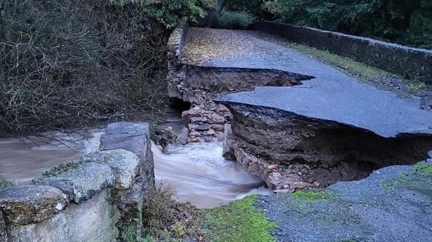
A bridge in north Louth has partially collapsed due to flooding in the Cooley Peninsula after heavy overnight rainfall.
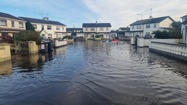
Humanitarian assistance will be made available to those affected in Louth and Wexford, Minister Heather Humphreys has confirmed.
She said that the income limits on the schemes will range up to €90,000 for couples, as high as €50,000 for a single person, and with up to €15,000 per dependent child.
She said: "I'm very conscious of the serious disruption that severe weather and flooding is causing for individuals and families in counties Louth and Wexford.
"The Humanitarian Assistance Scheme is open and support is available."
She said those who may need to access the supports can contact the Community Welfare Service by phoning 0818 60 70 80.
Warnings
A Status Yellow rain warning is in effect until 12pm tomorrow for Kerry, with localised flooding and difficult driving conditions forecast.
A separate Status Yellow wind warning for Clare, Kerry and Galway will be in effect from 5am until 11am tomorrow, with strong and very gusty westerly winds, accompanied by squally showers, which could result in difficult driving conditions and wave overtopping near coasts.
As Storm Ciarán approaches, a Status Yellow rain warning for Carlow, Kilkenny, Wexford, Wicklow, Cork and Waterford will be in operation from 7pm tomorrow until 7am on Thursday.
Speaking on RTÉ's News at One, Linda Hughes, Met Éireann Meteorologist, said: "So, rain has moved into the southwest already, so there is going to be wet weather across the country. It is going move northeastwards through today, tonight, tomorrow morning, so there is going to be wet weather right throughout that..."
She said that was a different low-pressure system tracking to the northwest of Ireland.
However, she said Storm Ciarán would track to the south of Ireland. "We are actually escaping the worst of the storm. It is going to impact the south of England and parts of France much more than us.
"It is going to bring some more rainfall into the south and southeast from tomorrow evening and into early Thursday morning, so there is Yellow rain warnings out for the south and southeast for that period."
'My heart goes out'
Minister for the Environment Eamon Ryan expressed concern for those caught up by the latest flooding.
"My heart goes out to those up in Cooley/Carlingford, down in Wexford I know there has been particular flooding, as well as Newry, as well as what happened to Midleton (Co Cork) obviously a few weeks ago," he said.
Speaking on RTÉ's Today with Claire Byrne, the minister said: "Those parts of the country in the south-east tend to be more at risk because of softer ground conditions at the coast. Because there's also a kind of a longer term trend in terms of that coastline lowering slightly and also obviously rising sea levels.
"So it is connected to climate change. We have to manage and protect our coasts and our people. We can do that, but we have to recognise the reality - the seas are rising, there are particular difficulties also with heavier rains coming, as well as the other elements of coastal erosion."
A Yellow rain warning for Antrim, Armagh, Down, Tyrone and Derry is in place until midday, while a separate Yellow rain warning for Antrim, Armagh, Down, Fermanagh, Tyrone and Derry will be in effect from 9pm tonight until 9am tomorrow.
Heavy rain associated with Storm Ciarán could also bring further disruption to the east of Northern Ireland on Thursday, with a yellow rain warning for Antrim, Armagh and Down in effect from 6am until midnight.
Motorists are advised to take extra precautions when driving this morning, as heavy rainfall across the country overnight has left the roads hazardous in some areas. Keep a safe distance from the car in front and exercise caution at all times. pic.twitter.com/HXqjGqEho6
— Police Service NI (@PoliceServiceNI) October 31, 2023
Stormont's Department for Infrastructure said police were warning people not to travel while the amber warning is in effect.
"These (Met Office) warnings follow an extremely wet weekend where flooding has already occurred on many roads," it said.
"The persistent wet conditions on saturated ground and with higher river levels this will inevitably lead to more localised flooding.
"Traffic disruption is possible, and the public are being asked to consider their journeys and take extra care if travel is necessary.
"It may be necessary to close roads or put temporary restrictions in place."
Gardaí are aware of flooding on the N1 between Junction 19 & 20 Northbound & the R173 in the Carlingford area in County Louth.
— An Garda Síochána (@GardaTraffic) October 31, 2023
Please take caution if you are driving in these areas.
Any road users planning to travel to these areas are asked to consider alternative routes. pic.twitter.com/EBA7NIDS4k
Senior Forecaster with Met Éireann Gerry Murphy said rain in north Louth and Ulster will clear today, but Storm Ciarán will push to the south coast tomorrow night and into Thursday.
He said that although the rain will not be excessive, there is a threat of flooding in areas with already heavily saturated lands.
Additional reporting: Mary Regan, Conor Macauley, PA


