Opinion: Dublin's history and ecology are paramount to understanding why proposals to move Dublin Port are not a good idea
By Emily Webster, UCD
According to the city’s more development-minded residents, there is a clear solution to Dublin's housing and real estate crisis: move Dublin Port. In February, the Docklands Business Forum submitted a proposal to the Dublin City Council for its 2022-2028 draft development plan calling for the relocation of the Port outside the city. They argued that 200 hectares of land currently occupied by the port could be better and more profitably used for housing and business developments.
The proposal was rejected immediately by Dublin City Council, who claimed that it would violate EU environmental law. However, it would be foolish to think that this will be the last time that businesses fix their eye on the port for redevelopment. With the continued housing crisis in Dublin and office space at a premium, the waterfront has been seen as an attractive site for expansion. The last controversy over moving the port was just two years ago.
We need your consent to load this rte-player contentWe use rte-player to manage extra content that can set cookies on your device and collect data about your activity. Please review their details and accept them to load the content.Manage Preferences
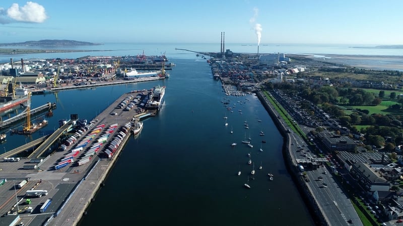
From RTÉ Radio 1's Seascapes in November 2021, Dublin Port Chief Executive Eamonn O'Reilly on ambitious plans for the Port
But looking back to the history of urban growth and ecology in Dublin shows us why these proposals could be a disastrous and expensive bit of developmental hubris. Though nearly a thousand years old, Dublin grew to resemble the present city in the early 18th century, after the Tudor Conquest of Ireland necessitated an administrative and logistical centre tying Ireland to England. British administrators chose Dublin as a site for the same reasons that the Vikings and their Anglo-Norman successors did: because it was an ecologically ideal place for a shipping port.
The Greater Dublin area is located within a drainage basin - a bowl-like structure created by the hilly topography into which water runs, forming the Liffey, Dodder, and Tolga rivers. The land slopes gradually towards the sea, emptying these rivers into Dublin Bay. The Liffey, the largest of these rivers, forms an estuary at its mouth.
We need your consent to load this rte-player contentWe use rte-player to manage extra content that can set cookies on your device and collect data about your activity. Please review their details and accept them to load the content.Manage Preferences
From RTÉ Archives, John Ross reports for RTÉ News in 1962 about the modernisation of Dublin Port's pilotage service
Historically, estuaries within catchment basins have been considered ideal for shipping because of the calmer waters and easy access to inland travel via the river. But it also means the land immediately surrounding the bay is extremely low-lying, and prone to flooding - and flooding poses major risks to both the city's infrastructure and the health of its residents.
Stories of flooding in Dublin are nearly as old as the city itself. According to the Dublin Historical Record, mentions of floods can be found in records dating back to 693, with frequent references to bridges across the Liffey being carried away in the 17th century. In the late 19th century, the young science of epidemiology linked urban growth on such a low-lying area to a major health crisis. Medical officers cited connections between constant flooding and water-borne illness, especially typhoid fever, which was rampant in the city far later than in similar cities in the UK.
The then Chief Medical Officer of Health for Dublin, Charles Cameron, established this relationship when he set out to solve the mystery of unusually high typhoid rates in Dublin. He reported that typhoid fever was especially bad in the areas of Clontarf, East Wall and the port, where the low, flat terrain kept the areas water-logged for days, while poor infrastructure for the environment meant that sewage also stagnated in these areas instead of flowing out into the Bay.
We need your consent to load this rte-player contentWe use rte-player to manage extra content that can set cookies on your device and collect data about your activity. Please review their details and accept them to load the content.Manage Preferences
From RTÉ Archives, Dermot Mullane reports for Newsbeat in 1965 on development plans at Dublin Port
Cameron observed that these areas were "low-lying, badly drained sites, saturated with foecal matter and other organic debris." He argued that this combination of infrastructure and environment was likely responsible for tens of thousands of cases of typhoid and other water-borne diseases among Dublin's residents in the late 19th century.
This battle between landscape and infrastructure has continued through the present. Sewers and sea-walls barely keeping pace with the growing city, as indicated by the infamous Hurricane Charley flood, recent episodes of severe flooding in Clontarf and ongoing struggles by Water Ireland to keep up with leakage and drainage problems.
We need your consent to load this rte-player contentWe use rte-player to manage extra content that can set cookies on your device and collect data about your activity. Please review their details and accept them to load the content.Manage Preferences
From RTÉ Archives, Charlie Bird reports for RTÉ News on the damage caused by Hurricane Charley in 1986
Perhaps most symptomatic of the city's under-investment in infrastructure is the current state of the Ringsend wastewater treatment plant. Constructed with Cameron’s support in 1906 and still the largest wastewater facility in Dublin, large sections of this critical infrastructure have recently "collapsed", necessitating major, expensive upgrades.
Even if infrastructure were to keep up with the growth and development of the foreshore, climate change is set to pose even greater threats to these low-lying areas. With sea level rise in the Bay reaching 6-7mm per year, nearly double the global rate, the Irish Sea is currently projected to submerge the port by 2050 and place an existing 20,000 homes at risk.
We need your consent to load this rte-player contentWe use rte-player to manage extra content that can set cookies on your device and collect data about your activity. Please review their details and accept them to load the content.Manage Preferences
From RTÉ Radio 1's News At One, Brainstorm contributor Dr Gerard McCarthy from Maynooth University on research which has found faster than expected sea level rises at Dublin Bay
Additional development of the port would only place more residents of the city directly within flood paths. Even in the modern world, the combination of poor infrastructure and flooding can breed disease, as the spike in cryptosporidiosis and E. coli infections in Ireland after the winter storms of 2015-2016 show.
Looking to long history of struggle between the city and its water sources, it's clear that developing the port would likely be a costly experiment in what history already tells us - that infrastructure can only get you so far when the ecology runs counter to your goals.
See Typhoidland for more on the history of typhoid fever in Dublin, Ireland and elsewhere
Dr. Emily Webster is a research fellow at the School of History at UCD.
The views expressed here are those of the author and do not represent or reflect the views of RTÉ