
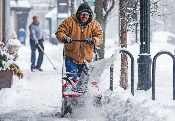
Two-thirds of the continental United States will be a frozen ice box today as the so-called polar vortex of frigid arctic air spins across the US midwest, clips the Great Lakes, the Ohio Valley and pushes on into New England.
The sub-zero cold and bitter winds will stick around for a couple of days, possibly bringing dozens of record lows of down to -60F with a life-threatening freeze before dissipating by the weekend, the National Weather Service (NWS) reported.
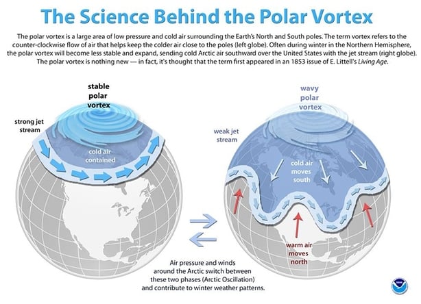
The polar vortex is a mass of freezing air that normally spins around the North Pole, but has slipped southward and swirled into the United States, forecasters said.
The hardest-hit area will be the midwest, where wind chill could bring temperatures as low as -50F (-46C) in the Chicago area by this evening.
A record cold air mass will continue into the central and northern U.S., spreading to the east coast on Tuesday. Wind chills of -30 to -60 can be expected over portions of the northern Plains and Great Lakes region. Please be safe.
— NWS (@NWS) January 29, 2019
Up to 60cm of snow is forecast across parts of Wisconsin and Illinois. Even Alabama and Mississippi could see snow, the NWS reported.
"This arctic air dumps out of Canada and will affect us for days," said Richard Bann, a forecaster with the NWS's Weather Prediction Center in College Park Maryland.
"We'll even get some snow this afternoon in the (Washington) DC area," he said.
"And because it's so cold, there won't be much of a warm-up Wednesday. You'll have to wait for the weekend, before you see any higher temperatures."
Blizzard conditions were predicted across parts of the western Ohio Valley and snow was expected through Wednesday from the Great Lakes region into New England.
More than 2,000 US flights have been cancelled and thousands of schools, universities, government offices and businesses have been shut across the region.
States of emergency have been declared from Wisconsin and Michigan, down to Alabama and Mississippi.
What is a polar vortex?
Dangerous wind chills expected over the entire region of the Northern Plains and Midwest. Stay safe!! #ndwx pic.twitter.com/qEJzCKldXf
— NWS Bismarck (@NWSBismarck) January 29, 2019
In Illinois, Governor JB Pritzker said wind chill could drive temperatures to -55F in northern parts of the state this evening, a level that can cause frostbite in a matter of minutes.
"This is a potentially historic winter storm that will bring extreme cold to our state and all Illinoisans must prepare," Mr Pritzker said.
Parts of north and central Georgia are expecting about 6-7cm of snow or more in the coming days, along with freezing rain and ice-slicked highways.
There's cold, and then there's COLD! Extreme and dangerous COLD! is forecast this week from the Northern Plains through the Great Lakes with lows in the -30s and -40s and wind chills as low as the -60s Wed-Thu! If you can't stay cozy inside, be sure to cover any exposed skin! pic.twitter.com/dJNpT0qGHs
— NWS (@NWS) January 28, 2019