Road users have been advised to take extra care on the roads this weekend with a Status Yellow wind warning set to take effect tomorrow.
The warning has been extended and will be in place from 1pm tomorrow until 2am on Sunday across the country.
Met Éireann has forecast strong winds to hit Ireland with the arrival of Storm Dave.
Senior forecaster Gerry Murphy said the northwest will bear the brunt of the storm, but it will be windy everywhere, especially from early afternoon onwards.
Speaking on RTÉ's Morning Ireland, he said counties Sligo, Donegal, Leitrim, along with Derry and Antrim, are "going to get some very strong winds through the evening".
Mr Murphy added that Storm Dave will also bring heavy rain but that the amounts of rainfall "will not be quite as impactful" before it clears tomorrow night.
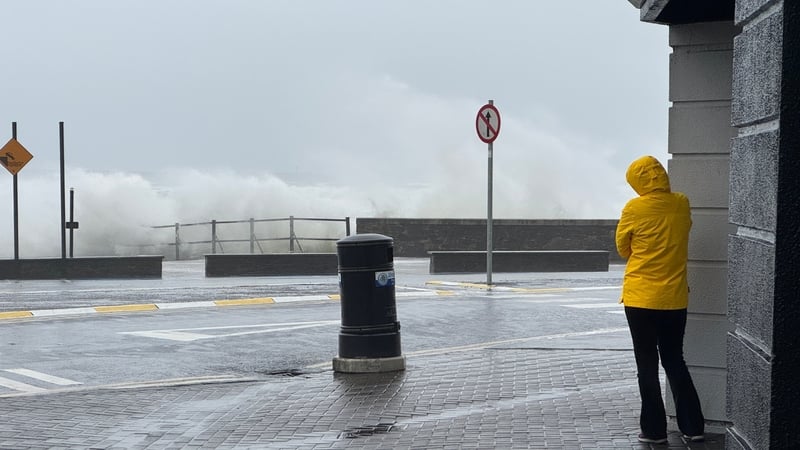
"The wind will be the major feature tomorrow and in addition to that, people need to be aware of waves as well.
"We will be in spring tides. We will have high tide during tomorrow afternoon, coupled with those very strong winds.
"There will be wave over-topping, possibly some localised flooding near coasts. So, people need to be very careful near the coast."
Iarnród Éireann Corporate Communications Manager Barry Kenny said there were no weather-related issues on the trains today.
Speaking on RTÉ's Drivetime, he said a Saturday timetable is operating on Commuter and DART services, and trains are less busy with fewer numbers of people at work.
On Intercity, he said the 24-hour period until this evening "will be the busiest time of the week".
"But everything is on the move and we have all of our trains out there ready to bring people to where they need to go," he added.
Director of Communications at daa Sarah Ryan said disruption at Dublin Airport is expected tomorrow on account of the storm.
She said disruption is expected "from around lunchtime" because "some very strong gusts" are forecast, which will impact runways.
"From about midday until about 8 or 9 o'clock tomorrow night, there may well be disruption.
"But as always we would advise passengers to be in touch with their airline, keep an eye on the websites, and still arrive for their flights two hours before short-haul and three [hours] before long-haul."
⚠️Yellow Wind Warning Updated⚠️
— Met Éireann (@MetEireann) April 3, 2026
⏲️Valid time is now 1pm Saturday 04/04 to 2am Sunday 05/04
All other information unchanged at this time.
ℹ️ https://t.co/GYji547FKt
ℹ️ https://t.co/d4K1ltldih pic.twitter.com/iuW4iygBky
Mr Murphy also urged all road users to take extra care when travelling this weekend.
The first of the rain will arrive tonight, followed by showers, some of which could be heavy, said Met Éireann meteorologist Mark Bowe.
He said the storm will "rapidly deepen" as it crosses from the north of Ireland towards Scotland, which will suffer the "brunt of the impacts of this, we're going to get the lead up to it."
'Expect the unexpected'
The Road Safety Authority has said that the control of a vehicle may be affected by strong cross winds while high-sided vehicles and motorcyclists are particularly vulnerable to strong winds.
It advised motorists to watch out for fallen debris, objects being blown onto the road and vehicles veering across the road.
It also said that drivers should allow extra space between themselves and vulnerable road users such as cyclists and motorcyclists as they may be blown off course by strong winds.
"Expect the unexpected," the authority said in a statement.
Corporate Communications Manager Iarnród Éireann Barry Kenny said there were no weather-related issues on the trains at present.
The UK Met Office also issued a Yellow wind warning for Antrim, Armagh, Down, Fermanagh, Tyrone and Derry, which will be in operation from 2pm tomorrow until 3am on Sunday.
It said the storm will bring a spell of very strong winds tomorrow into Easter Sunday morning, which may cause some damage and travel disruption.
Storm Dave will be the fourth named storm of the season, from a list of 21 names chosen by the Irish, UK and Dutch national weather services.