A Status Orange rain warning is in effect for Dublin, Wicklow, Waterford and Louth, while a Yellow warning is also in place for nine other counties as very heavy rain is expected over much of the east and southeast of the country.
Met Éireann is warning of heavy rain falling on already saturated ground, which could cause localised flooding, river flooding and difficult travel conditions.
The Status Orange warning for Waterford will be in effect until 9am tomorrow.
The Status Orange warnings for Dublin and Wicklow will be in place until 3pm tomorrow, while the warning for Louth is in effect until 6pm tomorrow.
Motorists in affected areas are being warned not to drive into flood water.
Iarnród Éireann said DART services are not running between Lansdowne Road and Dún Laoghaire due to flooding on the line.
It added that the Dublin to Rosslare train line is closed between Greystones and Kilcoole due to debris on the line, and is also closed between Enniscorthy and Wexford.
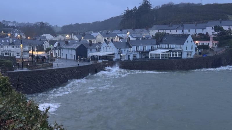
Flooding has been seen in Sandycove and other coastal areas of Dublin, with wave overtopping in places.
Watch: Flooding in Sandycove, Clontarf and Bullock Harbour in Co Dublin
Separately, a Status Yellow rain warning is in effect for Carlow, Kildare, Kilkenny, Laois, Wexford and Tipperary until 9am tomorrow.
Cavan, Monaghan and Meath are also under a Status Yellow rain warning until 6pm tomorrow.
In all cases, Met Éireann is warning that very heavy rain will fall on already saturated ground, which combined with high tides and high river levels, will lead to localised flooding, river flooding and difficult travelling conditions.
The UK Met Office has issued a Yellow warning for rain for Antrim, Armagh, Down, Tyrone and Derry, which will be in effect until midnight tomorrow.
Met Éireann senior forecaster Gerry Murphy said that "flooding is on the cards", but it is hard to define where it will hit.
He added that rainfall amounts are high, and urged people to be vigilant and prepare for the possibility of flooding.
Mr Murphy said the current weather system, which sees the low pressures hitting the south more so than normal, will continue today and tomorrow and further bands of rain next week will mean unsettled weather.
Some flood relief schemes 'taking too long' - Taoiseach
The National Emergency Co-ordination Group is warning of possible flooding.
The NECG also urged those in the affected areas who can work from home tomorrow to do so "in order to free up roads for essential services".
Line remains closed between Lansdowne Road and Dun Laoghaire, flooding to platform height at Salthill earlier this https://t.co/560AnEQPQd pic.twitter.com/JZCel3xRda
— Iarnród Éireann (@IrishRail) February 5, 2026
The group said local authorities are "monitoring the situation closely and actively responding to the weather conditions and associated flood risks".
It said the Irish Red Cross and Civil Defence are also available to provide support where necessary.
Taoiseach Micheál Martin has said that some flood relief schemes are "taking too long to bring to fruition".
But he said such measures were complex and involved a range of different challenges.
"We are going to do everything we can to accelerate these flood relief schemes, get decisions made... but we need to look more at interim solutions as well," he said.
Speaking in Co Galway, Mr Martin said that over the last number of years there had been different manifestations of changing weather patterns, which, in his view were "clearly caused by climate change".
Mr Martin said discernible progress had been made in terms of the way the country responds to such issues, since Storm Éowyn in January 2025.
We need your consent to load this rte-player contentWe use rte-player to manage extra content that can set cookies on your device and collect data about your activity. Please review their details and accept them to load the content.Manage Preferences
Councils prepare for flooding
Wicklow County Council said it has taken a number of preventative measures, including outdoor crews working to clear drains and gullies that have become blocked with flood debris.
The council said its crews are prepared and ready to respond to areas likely to be impacted by forecast high intensity rainfall while stocks of sandbags have been replenished and are available at depots across the county.
It added that roads subject to flooding and structural damage have been closed to traffic and that work continues to assess the scale of damage caused to the road network.
Watch: A car being driven through a flooded road in Sandycove in Dublin
Waterford City and County Council is making sandbags available in some of their depots and is advising people to stay away from coastal areas.
Wexford County Council said roads are flooded in places where motorists might not ordinarily expect flooding.
The council had installed aqua dams along exposed parts of the quay in Wexford town ahead of high tide around 9am and removed them after the high tide passed without incident.
The council said that much of the spot flooding and pooling of surface water is caused by run-off from land, which combined with full drainage systems, will take time to recover.
High coastal levels will reduce the capacity for river discharge and increase flood risk in low-lying areas, especially at high tide, it said.
The council added that high spring tides for the remainder of the week, combined with strong winds and surge, may cause wave overtopping and coastal flooding in places.
Significant risk of flooding in parts of Co Louth
Parts of north Louth are at a significant risk of flooding due to heavy rainfall over the next 24 hours.
Authorities have warned that impacts expected in Co Louth over the will be "inevitable", with heavy rainfall, coastal flooding, run-off from mountains and rivers expected to burst their banks.
Heavy rain is causing swollen rivers and streams, and Louth County Council has said there are a number of areas of concern, particularly in the north of the county.
Director of Services David Hanratty has said that the Cooley Peninsula is particularly at risk.
"Our main concerns are in the north of the county, particularly in Cooley and the Cooley peninsula where there is going to be significant rainfall over the next 24 hours. That will quickly travel into already swollen rivers, and that will have impacts."
He said that 30-60mm of rain is forecast for Cooley over 24 hours, which was a "significant step up on the amount and the intensity of rain" that came during Storm Chandra.
Mr Hanratty said that while Louth County Council crews have been distributing sandbags to areas that are likely to be affected, be said the impacts would be inevitable.
Run-off from the mountains in parts of the Cooley Peninsula is also of concern, particularly in Carlingford and Omeath, which have been impacted in the past.
There is also a significant risk that three rivers, the Fane, the Glyde and the Dee, will burst their banks over the next 24 hours, along with the tributaries that flow into them.