A Status Orange rain warning has been issued for Wicklow and Waterford, and a Yellow alert for nine other counties, with more flooding likely.
The Yellow warning is for Carlow, Dublin, Kildare, Kilkenny, Laois, Louth, Wexford, Monaghan and Tipperary.
Both will come into effect at 3am tomorrow and last for 24 hours.
Met Éireann said that heavy rain falling on saturated ground, combined with high river levels and high tides, will lead to localised and river flooding, as well as difficult travel conditions.
Motorists in the southeast are being warned not to drive into flood water.
Wexford County Council said that it is "dangerous and unpredictable, and even shallow water can hide strong currents, debris and open drains".
It said that roads are flooded in places where motorists might not ordinarily expect flooding.
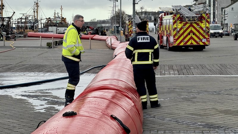
The council is installing aqua dams along exposed parts of the quay in Wexford town ahead of high tide tomorrow morning.
The council said that much of the spot flooding and pooling of surface water is caused by run-off from land, which combined with full drainage systems, will take time to recover.
High coastal levels will reduce the capacity for river discharge and increase flood risk in low-lying areas, especially at high tide, it said.
The council added that high spring tides for the remainder of the week, combined with strong winds and surge, may cause wave overtopping and coastal flooding in places.
Watch: Drone footage shows scale of Enniscorthy flooding
Wicklow County Council said its teams are monitoring the situation and identifying potential impacts in the county.
It said that requests for sandbags are subject to an assessment of need the availability of stock.
The council urged people to stay away from coastal edges, noting that road closures are in place in certain areas affected by previous flooding.
Meteorologist with Met Éireann Michelle Dillion said that for an Orange warning over a 24-hour period, between 50mm and 80mm of rain has to fall "and up to double that on the windward side of mountains".
Speaking to RTÉ's Drivetime, Ms Dillion said coastal flooding is also a risk during the latest rain warnings because of high tides and "strong onshore winds" with easterly winds and "storm surge".
"We're looking at higher-than-usual spring tides, so at times of high tide we're looking at some coastal flooding too.
"And the added complication is those high coastal water levels will impede river discharge and increase flood risk in low-lying coastal and estuarine areas," Ms Dillon said.
Ms Dillion said the peak of the the high tides will be tomorrow and Friday before there is a "gradual return over the weekend".
She said some rivers take longer to respond to rainfall than others "so hopefully a little bit of a buffer there for some catchments..."
Ms Dillion urged the counties within the Orange and Yellow warnings to be "on alert" for flooding, especially the river catchments downstream from Wicklow Mountains.
Because of saturated ground "it won't take too much more rainfall to cause more river flooding and then the added complication of the coastal flooding".
She said this weekend looks drier but it will remain unsettled into next week with low pressure "continuing to dominate" the weather.
Ms Dillion added that after a reprieve today, more rain will "push up from the south tonight, through tomorrow, followed by heavy showers and then actually another band of rain Thursday night into Friday followed by more heavy showers".
Dublin, southeast at high risk for flooding
Parts of Dublin and the southeast of the country are at high risk of flooding, according to the National Director for Fire and Emergency Management.
Speaking on RTÉ's Morning Ireland, Keith Leonard said the key time will be tomorrow night.
"The Nore, the Barrow, the Slaney and the Liffey [river] catchment are going to see very high levels right across this evening and into tomorrow," he said.
Mr Leonard added that local authorities are sharing resources and equipment is being moved from less affected areas to key pinch points, with interim solutions, such as an aqua dam in Enniscorthy, being put in place.
The town was one of a number of areas to be hit by heavy flooding last week after Storm Chandra hit.
Parts of south Dublin, including Rathfarnham, were also badly affected after the River Dodder burst its banks.

Mr Leonard said that "absolutely every engineering solution and every kind of interim measure that can be taken is being taken to try and deal with these almost record-breaking levels of water right across those catchments".
In relation to farming, he said: "This is about as bad a weather as you could have for that type of situation.
"Hopefully there'll be some respite shortly, but no doubt, extremely difficult conditions across the agriculture sector."
Watch: Wexford County Council is preparing for 'very high tides' in Wexford harbour
103 applications for Emergency Response payments
Tánaiste Simon Harris told his Fine Gael colleagues tonight that more than 100 homes have applied for financial assistance following the devastating floods.
The Finance Minister said 103 Emergency Response Payment claims have been applied for with many more expected.
At the weekly parliamentary party meeting, the Fine Gael leader said ten applications have been made to date by businesses and community, voluntary and sports organisations to their relevant flooding scheme.
Mr Harris said a Cabinet sub-committee will soon meet to examine the early weather warning system and the governance structure of the oversight body for future adverse weather events.
We need your consent to load this rte-player contentWe use rte-player to manage extra content that can set cookies on your device and collect data about your activity. Please review their details and accept them to load the content.Manage Preferences
Additional reporting by Petula Martyn

