
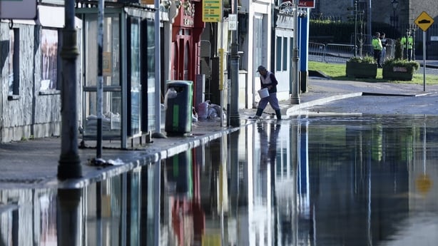
Surface water levels have begun to increase parts of Kilkenny and Wexford this evening, while a Status Yellow rainfall warning remains in place until midnight.
The situation is also worsening tonight in Enniscorthy where they have been closed tonight due to flooding. However, the extent of the flooding in the town over the coming hours is not expected to be as bad as earlier in the week.
Meanwhile, south Co Wexford has experienced widespread flooding tonight. Many roads have been closed in the Bridgetown, Carne and Lady's Island areas.
The rainfall warning also covers counties Carlow, Dublin, Louth, Wicklow and Waterford.
Met Éireann had warned that even a small amount of rain could lead to renewed flooding on ground already waterlogged by Storm Chandra.
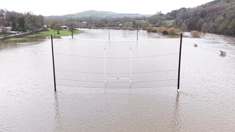
Flooding hit Co Kilkenny throughout today after the Nore and Barrow rivers burst their banks while Enniscorthy is on high alert as the Slaney rises.
Properties in several parts of the county have been affected, including Graiguenamanagh, Thomastown, Inistioge and Callan.
However, the exact number of homes and businesses to have been flooded is not yet known.
Watch: Flooding seen in Graiguenamanagh in Co Kilkenny
Officials with Kilkenny County Council have said intense rainfall yesterday evening - together with flood waters coming downriver along both the Nore and Barrow catchment areas - resulted in significant flooding at the locations.
Council crews operated through last night in Kilkenny with water pumps in Graiguenamanagh, while fire crews worked at a number of properties in Thomastown to pump flood waters.
Sandbags are available at several locations in impacted areas and supply will be maintained, the council said.
Watch: Flooding seen in Thomastown in Co Kilkenny
The other counties under the Status Yellow rainfall warning are also bracing for the impact.
In Wexford, water levels have been rising steadily again in Enniscorthy. Residents were this afternoon advised to leave their homes.
Wexford County Council said that river levels are rising quickly this evening and conditions are expected to worsen over the next 24 hours.
"Please do not to bring children anywhere near flooded areas as the water is flowing rapidly and there may be underlying manholes that have become dislodged and other debris from lands and the river," it said in a statement.
"At this point, floodwaters should be treated as contaminated."
Earlier today, the council warned of "a continued high risk for flooding for the Slaney, and particularly Enniscorthy town, right through the bank holiday weekend".
The council noted there was "an accumulated rainfall of 79.6mm" between 22 January and 28 January, adding repair work is "ongoing around the county, to damaged roads, pipes and manholes".
Read more:
Live: Updates as they happen
Accumulation of rainfall caused Storm Chandra flooding - climate study
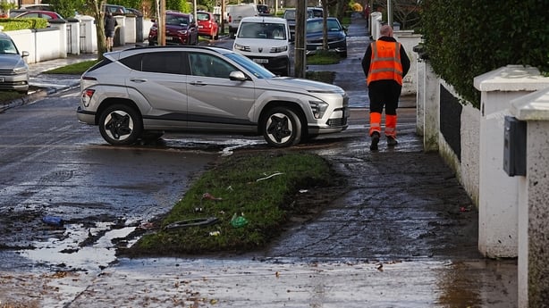
South Dublin County Council echoed advice from Wexford County Council, urging people to be aware that the risk of flooding persists due to high river levels and the saturated ground.
"Crews are currently working on clean up, debris removal and flood protection preparation," it added.
Senior Forecaster with Met Éireann Gerry Murphy said that the Status Yellow rain warning remains in place until midnight.
Speaking on RTÉ's Drivetime programme, he said a band of rain is pushing up from the southeast this evening.
He said that, over three hours this afternoon, another 10mm of rain was recorded at Johnstown Castle in Co Wexford.
"With that type of rainfall there is the potential for flooding across the southeast.
"A good part of the eastern half of the country is also at risk - even up to parts of Monaghan, Louth, east Cavan. Because the bucket is full, it takes very little to tip it over," Mr Murphy said.
The National Emergency Co-ordination Group urged the public to remain vigilant over the coming days, with the risk of flooding expected to continue into the long weekend.
Speaking this morning, chairperson Keith Leonard said the group was preparing for another "difficult day" for many parts of the country.
The Road Safety Authority advised road users to "take care on the roads" following heavy rainfall this week.
Translink said it was operating "a reduced timetable" on the route between Belfast and Dublin due to flooding. "Bus transfers will operate to Newry," it said.
A rapid study of Storm Chandra by climate scientists found it was the accumulation of rainfall over seven days, including on the day of the storm, that caused this week's flooding to be so devastating - not the actual amount of rainfall that fell during the storm itself.


