The east and south east of the country are braced for further possible flooding with more heavy rain forecast overnight on already saturated ground.
A Status Yellow rain warning for counties Dublin, Carlow, Kilkenny, Wexford, Wicklow, and Waterford is in effect for 24 hours.
Met Éireann warned that heavy rain, combined with saturated grounds and high river levels, could lead to more flooding.
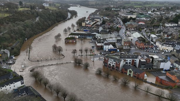
The warnings comes as communities across the east and southeast hit by heavy flooding continue to assess the damage following Storm Chandra.
A Status Yellow rain warning has also been issued by the Met Office for Northern Ireland, from midnight until 6pm on Friday.
⚠️Yellow Rainfall Warning
— Met Éireann (@MetEireann) January 28, 2026
➡️Carlow, Kilkenny, Waterford, Wexford, Wicklow & Dublin
⌛️00z Thursday to 00z Friday
Further heavy rain/showers falling on saturated ground, combined with high river levels may cause further flooding & difficulty travelling
ℹ️https://t.co/GYji547FKt pic.twitter.com/8WlgdVZAGs
Heavy winds and torrential rain on Tuesday caused significant disruption across the island of Ireland, including power outages, flight cancellations and 300 school closures in Northern Ireland.
Rivers burst their banks, including the Slaney in Co Wexford and the Dodder in Dublin, with fallen trees reported across the island.
Minister for the Office of Public Works (OPW), Kevin Boxer Moran, will visit the areas worst affected by Storm Chandra - south Dublin, Co Wicklow and Enniscorthy, Co Wexford.
The water has been receding in Enniscorthy where the River Slaney burst its banks, causing major flooding.
Several parts of Enniscorthy town centre were impassable on Tuesday with dozens of homes and businesses under several metres of water.
Glass bottle and food waste bins had been left out in Enniscorthy on Monday night, leaving the streets littered with broken glass and food after the water receded.
National Director of the National Directorate for Fire and Emergency Management Keith Leonard said that the flooding in south Dublin on Tuesday caught authorities by surprise.
The areas most severely hit, he added, were Aughrim, Co Wicklow and Bunclody and Enniscorthy in Co Wexford.
Speaking on RTÉ's Morning Ireland, Mr Leonard said that Met Éireann had issued a high and elevated risk of flooding to all local authorities in the east before Storm Chandra.
"Local authorities were very aware of what was coming down. Unfortunately, south Dublin particularly caught us a little bit by surprise. We just weren't expecting those levels of rainfall that fell."
Read more:
A look back at rolling updates
Enniscorthy locals assess 'completely devastating' flood damage
'We're disgusted' - Dublin residents angry at flood relief scheme delays
Storm Chandra: 'Weather bomb' storms becoming more common
Mr Leonard said that local authorities will be vigilant up until the weekend, with emergency services remaining on standby.
Met Éireann has established a first phase of flood warning, and is bringing a second phase into operation, which it is hoped will improve localised flood warnings, but it is not at that point yet, he added.
Householders, business owners and farmers - whose property was damaged by Storm Chandra - are being encouraged to apply for the Emergency Response Payment.
The income-tested support is available to those who are unable to afford the costs to replace home items and for structural repairs.
Meanwhile, Minister for Enterprise Peter Burke is to seek Government approval to open the Emergency Humanitarian Flooding Scheme for impacted businesses, as well as voluntary and sports organisations.
The initiative would help businesses with up to 20 employees by providing a financial contribution of up to €5,000. Additional support may also be available.