
Storm Chandra was another "weather bomb".
That's the tabloid term for a storm that has undergone a process known as explosive cyclogenesis just before it hits.
It occurs when the air pressure at the centre of a storm drops by more than 24 millibars in 24 hours, which is very rapid.
This causes the winds to accelerate to fierce speeds with all the dangers for life and property that entails.
Chandra is the tenth time over the past ten years that the term explosive cyclogenesis has explicitly been ascribed to a named storm by either Met Éireann or the UK Met Office.
Although this "explosive" phenomenon is not considered a rarity in this part of the world, one can’t help feeling it’s becoming more common.
Up to and including today, six of those ten weather bombs have occurred in the past five years.
That seems like a lot.
The ten include Storms Dorris in 2017, Gareth in 2019, Denis and Alex in 2020, Barra in 2021, Eunice in 2022, Ciarán in 2023, Ashley in 2024, Éowyn in 2025, and now Chandra in 2026.
Chandra did of course bring strong winds.
Gusts of 130km/h were recorded at Malin Head in Donegal at 9am, and 87km/h at Dublin Airport at 3pm yesterday.
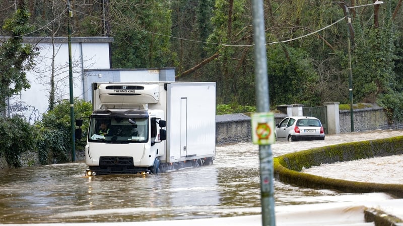
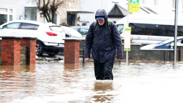
However, it is the impact of the rain Chandra brought, rather than the wind, that really stands out.
People not prepared for flooding
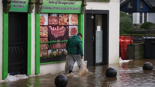
Despite the warnings and forecasts from Met Éireann about this storm, it is undeniable that people have been totally surprised by the flooding.
They were not prepared.
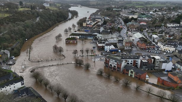
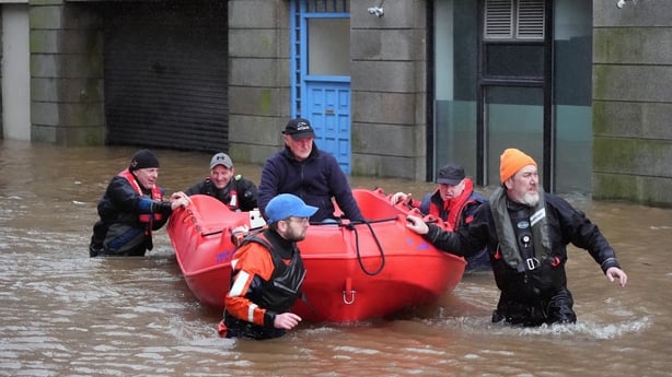
We have seen devastating flooding in Enniscorthy, in Enniskerry, in parts of Dublin, and elsewhere on the east coast on news bulletins.
Homes have been destroyed and streets turned into rivers as the Slaney, the Dargle, the Dodder and many other rivers burst their banks.
The traffic disruption was monumental, with people stuck for hours going nowhere because of the flooding.
Many say the yellow rain and wind warnings for Storm Chandra did not reflect the impact of the flooding that has resulted.
Met Éireann forecasters did warn that the large amount of rain Chandra would cause significant flooding.
They said repeatedly that the land was already saturated after heavier than normal rainfall in recent days and weeks.
Met Éireann also clearly warned about rivers overflowing and bursting their banks, about the coastal over-topping, terrible driving conditions, and traffic disruption because of localised flooding.
However, the fact that Storm Chandra came so fast could be part of the reason why many in the east of the country had not fully grasped the flood risks it would bring.
Supercharged jet stream
Many parts of the United States are in the grip of extremely cold weather right now.
This has caused a much sharper than usual contrast in temperatures between warm and cold on that continent.
Read more: Major clean-up operation following Storm Chandra flooding
This very sharp temperature contrast is supercharging the jet stream - the narrow band of fast flowing air, about 10km up, blowing from west to east that drives our weather patterns.
This super-charged jet stream is what brought the storm our way. However, Storm Chandra did not develop fully until it was very close to Ireland and the UK.
Even as late as Monday afternoon, meteorologists at the UK Met Office said they were still unsure precisely where the eye of the storm would pass.
They explained it could pass up over the Irish Sea on the UK side, or on the Irish side, or it could shift course and travel up the west coast of Ireland. They simply could not tell even at that late stage.
Whichever route it took, they said, would influence wind direction and the impact it would have.
In the event the eye of the storm passed up the west coast of Ireland and the winds and rain it brought spiralled in from the east.
The big issue of course, considering the flooding and devastation that has resulted, is could the Irish public have been better prepared.
Public data
There is real-time public data about rivers, freely available, that could be very useful for assessing the risk of local flooding.
The Office of Public Works operates a network of 380 hydrometric stations across Ireland.
These stations measure and record real-time data about water levels and water flow in rivers all over the country.
It is available for anybody to see and use on the waterlevel.ie website.
The network includes several river monitoring stations on the River Slaney in Enniscorthy which burst its banks.
There are stations on the Dodder River in Dublin and the Dargle River in Co Wicklow, which also burst their banks.
This hydrometric data could provide a huge insight into the risk of local flooding.
It tells you how high the water in a river is, how long it has been high for, how fast the river is flowing, and much more.
It can tell this information for 380 locations around the country, yet the public is not aware of it and it does not appear to be used locally to warn of flood danger.
There is other data too that could be better used for local flood warnings.
Met Éireann for instance has great data on soil moisture content and local and regional rainfall amounts that is geared for farmers.
Their data shows how much rain has fallen in any area over any particular time, how it compares to the usual rainfall in that area, and how saturated or dry the soil is in any region of the country.
Of course, their forecasters do refer to this information in a general way when speaking about saturated soils and the risk of rain running off the land and causing flooding.
But that data could be broken down to smaller local areas and combined with the river hydro station data from the Office of Public Works, could create a powerful tool for warning about local flood risks.
Climate scientists have been very clear that Ireland will have to adapt to more extreme rainfall and flooding events as climate change progresses.
If we don’t get better at local flood risk management, then that is going to mean more health and safety risks, more property damage, more traffic disruption and impacts on commercial activities just like we have experienced with Storm Chandra.
Very detailed real-time data about water levels and water flows at 380 river locations is freely available.
It is under-used.
Surely, in this age of artificial intelligence and super computers, this data could be combined with other regularly collected rainfall data to produce an impactful warning system for local flooding so that people, property and livelihoods can be better protected.


")