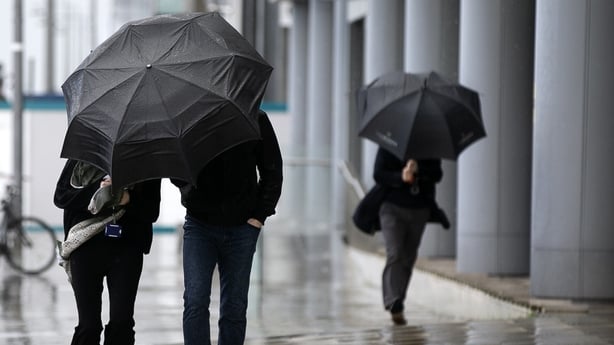
Two Status Orange wind warnings have been issued for 18 counties as Storm Bram is set to bring strong to gale force winds tomorrow, strongest in coastal areas.
The first alert will be in place for Cork, Kerry, Waterford and Wexford from 7am to 3pm.
The second warning will come into effect at 10am for Clare, Limerick, Donegal, Galway, Leitrim, Mayo and Sligo and will remain in place until 9pm.
This was extended tonight to Cavan, Longford, Monaghan, Offaly, Roscommon, Tipperary and Westmeath.
The rest of the country will be under a Status Yellow alert from 6am until 9pm tomorrow.
Senior forecaster at Met Éireann Gerry Murphy said that Red level winds could be recorded in Kerry and Clare.
Very strong to gale force winds are expected to become confined to west and northwest counties later in the day.
A Yellow wind warning, from the UK Met Office, will be in effect for counties Antrim, Armagh, Down, Fermanagh, Tyrone and Derry from 9am to 9pm tomorrow.
A Status Red Marine Warning has been issued for coastal areas from Mizen Head to Slyne Head to Malin Head.
Met Éireann said that south to southwest winds would occasionally reach violent storm force 11 tomorrow.
The alert will be valid from 12pm until 11.30pm.
‼️ #StormBram Update
— Met Éireann (@MetEireann) December 8, 2025
🟠Counties Added to Orange Level Wind warning:
📍Tipperary, Offaly, Roscommon, Longford, Westmeath, Cavan & Monaghan.
⏲️Valid: Tue 9th Dec 10:00 until 21:00
ℹ️https://t.co/t2JoveRUyC pic.twitter.com/1XDdtctc0l
A Status Yellow rain warning for seven counties came into force tonight.
The alert - for Carlow, Kilkenny, Wexford, Cork, Kerry, Tipperary and Waterford - is in place until 9am tomorrow.
The forecaster said that heavy rain will fall on "already saturated ground" and warned of the potential for flooding in low-lying coastal areas, especially during high tide, as well as localised flooding and difficult travel conditions.
System to deepen rapidly on approach to Ireland
Met Éireann said that a low-pressure system in the Atlantic Ocean is deepening rapidly as it approaches Ireland and has the potential to become an impactful event.
Mr Murphy said there is a "significant chance" of coastal flooding along the south and west coasts at high tide tomorrow morning, and along the east coast during the afternoon.
Speaking on RTÉ's Six One, he said this could exacerbate the possibility of river flooding because the rivers cannot get out to the sea.
He said that although there will be yellow level rainfall amounts, there could be an orange level flood risk due to the fact that the rain will fall on already saturated ground.
Mr Murphy said orange level winds will be on the "higher side" of the alert from Galway Bay northwards.
"With an orange level warning there is the risk of structural damage and falling trees, and we know how much damage falling trees have caused over the past year," he said.
"In previous storms people have actually been killed by falling trees, so an orange warning has to be taken very, very seriously."
‼️ Update:
— Met Éireann (@MetEireann) December 8, 2025
🔴Status Red - Marine Storm Warning extended to include coasts from Mizen Head to Slyne Head to Malin Head.
➡️Expect stronger gusts on these coasts.
➡️South to southwest winds will occasionally reach violent storm force 11.
⏲️Valid: Tues 09/12 09:00 to 23:30 pic.twitter.com/bNNLsfgefn
The National Directorate for Fire and Emergency Management chaired a meeting of the various stakeholders ahead of the arrival of Storm Bram.
Its Director Keith Leonard said it is important that people keep up to date with weather warnings tomorrow as they could change.
Speaking on RTÉ's Drivetime, he said local authorities have been preparing for the event since yesterday and their severe weather assessment teams are on standby.
He advised event operators to closely monitor the weather forecast.
"Particularly along the west coast tomorrow afternoon and evening, I think there may be a call needed to be made for a number of event organisers to maybe either close early or cancel events," he said.
People advised to avoid Cork city centre tomorrow morning
Cork City Council said there is a risk of tidal flooding on low-lying quays in the city centre during high tide tomorrow morning.
It warned commuters that road closures and traffic restrictions will be necessary between 8am and 9am and urged people to avoid travelling into the city centre until after 9.30am tomorrow.
The council urged householders and businesses to take precautionary measures to protect their properties from flooding.
Flooding is likely on Morrison's Quay, Father Mathew Quay, Father Mathew Street, Union Quay, Trinity Bridge, South Terrace, Rutland Street, Sawmill Street, Lavitt’s Quay, Kyrl’s Street, Kyrl’s Quay, Crosses’ Green, Sharman Crawford St and Wandesford Quay.
The council advised motorists not to park in any of these areas before 9.30am tomorrow.
Waterford City and County Council said that Storm Bram will be a "multi-hazard" event and urged people to exercise caution, heed all public safety advice and not make any unnecessary journeys during the Orange alert.
"If you must travel, motorists are advised to slow down, be mindful of vulnerable road users such as pedestrians and cyclists, increase stopping distances and watch for surface water and debris on the roads.
"Motorists should also avoid driving through flowing or standing water as the depth of the water can be deceptive," he said.
A number of car parks in Dungarvan, which are at risk of flooding, are closed and motorists were advised not to leave their vehicles there overnight.
Sandbags are being made available to people at the council's sites in Dungarvan and Carrickphierish in the city.
Extra bed capacity for homeless people is available at McGwire House.
Tipperary County Council urged people to stay away from swollen rivers, streams, and flooded riverbanks.
Additional reporting Marc O'Driscoll