
Dublin City Council will begin its plan to remove traffic from the city centre from August, Minister for Transport Eamon Ryan has said.
Today the council published an outline of how it is going to do this, with some radical changes that could see core traffic levels reduced by up to 60%.
Many areas of the city centre would see changes under it - and new public spaces, cycling infrastructure, and pedestrian facilities are at the centre of the blueprints.
The council's aim is to reduce the overall traffic running through the city centre, and instead encourage motorists to go around the city instead.
But with that, it said it wants to maintain a balance that will still allow for more essential movement such as deliveries.
Overall it said that a reduction will help achieve the city’s 2022-2028 Development Plan.
It said that these changes will not be put in overnight, but would instead be implemented in a phased manner between now and the end of that plan's timeline.
Here is a breakdown of each area and what is being proposed within it.
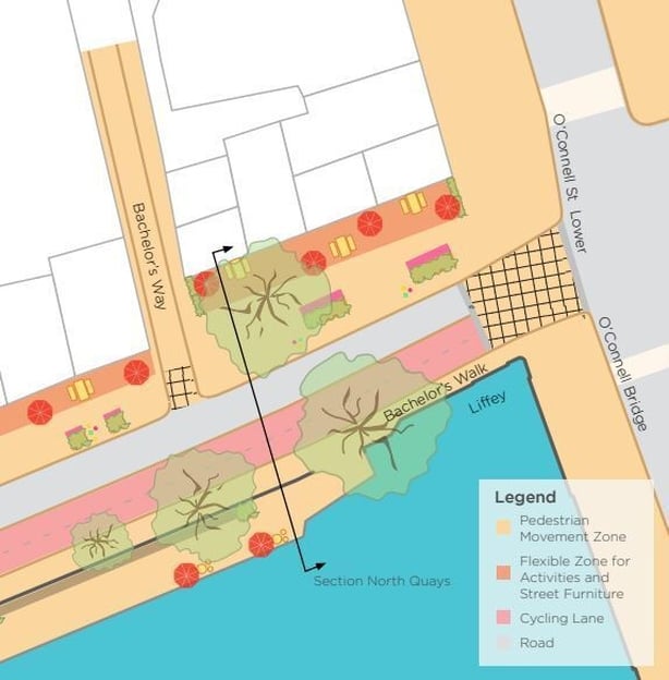
Bachelors Walk and Aston Quay
Only buses, taxis, cyclists and pedestrians would be permitted along these two quays that run along the Liffey's northern bank.
The council said that the BusConnects plan has put some emphasis on the river's quays and a need to reduce traffic on them, and it also said this change would help facilitate the planned Liffey Cycle Route too.
The removal of other traffic would free space and help both of these.
It also said removing traffic from there would help make the O’Connell Bridge junction more efficient and could allow for widened footpaths and longer pedestrian signal times.
Westland Row and Pearse Street
Only public transport vehicles and cyclists would be permitted to turn left from Westland Row onto Pearse Street, and a new right turn for general traffic will be introduced.
This would make a section of Pearse Street between the junction at Westland Row and Sandwith Street two-way.
The council said Westland Row is another area that is important under the BusConnects plan, and that although it will no longer be a through road to access Pearse Street, it will remain an option for motorists intending to travel towards Samuel Beckett Bridge.
The council expects that this change would facilitate better cycling and pedestrian infrastructure in both the Pearse and Tara Street areas.
There is an extra focus on both of these areas due to the DART+ plan as well as the MetroLink plan in the medium term.
These changes could also potentially lead to the creation of a new opportunity at Lincoln Place, which could become a more recreational space.
Beresford Place and Gardiner Street
DCC said that the result of the changes on Pearse Street and Westland Row would mean a knock-on effect for these two streets.
It gave two potential changes that could be made.
The first is that Beresford Place would go from one-way to two-way, while traffic on Gardiner Street would be cut from four to two lanes, due to the two southside streets no longer being main connecting arteries.
Cutting the lanes on Gardiner Street would allow for safer pedestrian and cycle use, it said.
It said general traffic coming from the southside would have to divert by Custom House Quay before connecting to Gardiner and Amiens Street at Memorial Bridge.
The council said this change will also bring an opportunity for a new public space extending from the northside area of Liberty Hall to the Custom House.
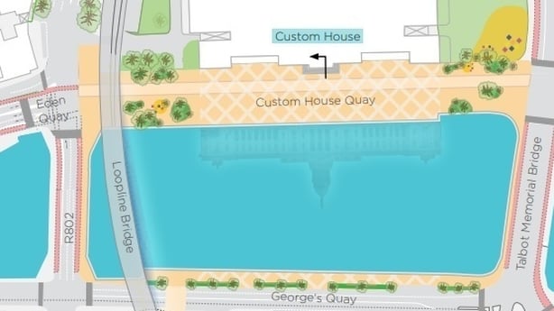
The alternative opportunity it outlined would be to reduce the amount of lanes from Liberty Hall to Custom House, again bringing more opportunity for cycling and pedestrian space there.
Under this plan Beresford Place would remain one-way, but with a contra-flow for buses and cyclists.
The proposals for Gardiner Street could still be taken forward under that option. Both of the ideas will be put to consultation.
The changes here could also potentially lead to a new civic space by Liberty Place.
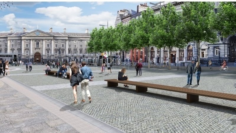
College Green and Dame Street
Limited access is again planned for this area, and will be phased in conjunction with the BusConnects plan.
The council said it will remove all traffic from Trinity College up to the junction with George’s Street eastwards.
Deliveries and limited access would still be facilitated.
This would make College Green a completely traffic-free area, and the project will see it turned into a "world-class, multi-functional public space", DCC said.
"This specific measure will be phased in conjunction with the implementation of the BusConnects service changes to ensure that bus services are facilitated until the new routes operating away from College Green and Dame Street are introduced," the plan said.
It said it would monitor bus journey times along the rest of Dame Street to Christchurch to try and identify any potential further measures to take.
It said reconfiguring the bus network around the Dame Street to Christchurch stretch may possibly allow for wider footpaths and improved cycle lanes.
It noted the Christchurch junction as a key tourism area, and a key objective of the plan is to reclaim road space around it.
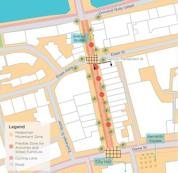
Parliament Street
The council wants to implement a similar scheme on Parliament Street as it did on Capel Street.
It said both traffic and public transport would be removed here and only pedestrians and cyclists would be permitted.
Delivery access would be done in a similar way to Capel Street, and a two-way cycle link across Grattan Bridge could be rolled out.
South Quays
The council said the south quay of the Liffey would be reserved for public transport, walking, and cycling only.
It also said there is a potential for a new boardwalk along it.


