
Visitors to DC from Ireland will be most familiar with Dulles, the main international airport for the Washington capital region, a conurbation of five million people.
But most Washingtonians would call Reagan National their local airport.
Its for domestic, internal US flights, and its busy: an average of 388 takeoffs and landings each day. 25 million passengers in the last reporting year (2023).
I've used it quite a bit. Close to the city (a 15-minute cab ride from the office, traffic permitting), connected to more than 90 cities in the US, efficient and constantly moving.
I've also flown American Airlines quite a bit - they are the biggest operator at National (DCA on the baggage tags). And I am familiar with the smaller aircraft, like those from Embraer and Bombardier - including the RCJ700 type that went down overnight.
Nothing bigger than a 737 can operate out of this tight airfield by the river. So this story is a bit closer to home than most.
Within an hour of the collision, we were driving across the Potomac to the Virginia side, to try and get as close to DCA as possible.
My cameraman wondered aloud about his son, airborne at that moment, on his way back to DC from another assignment (Junior is a cameraman too).
"It could have been him. It could have been us," he remarked, thinking of all the flights we had taken from here, especially the times we landed in darkness, the final seconds spent racing over the darkness of the Potomac.
I reminded him that the last big aircrash in the US was 15 years ago, in Buffalo New York, on the Canadian border. Think of all the millions of flights and hundreds of millions of passengers in that period.
Statistically flying is a very, very safe form of transport - probably the safest. But when it goes wrong, we tend to see it.
Traffic was light around 10pm as we neared Arlington cemetery (DC is an early to bed, early to rise town), but suddenly got snarled up as we neared Pentagon city.
The Pentagon itself - the massive office complex that houses the US Department of Defence, is pretty much the first thing you see when you take off from Reagan National - if you are on the left hand side of the plane.
The off ramp we wanted was blocked by police, trying to control the area around the airport and keep it free for emergency vehicles.
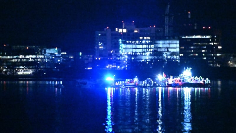
We followed the diversions, making for Alexandria, an old Georgian town that predates Washington DC, then doubled back to the small Marina at Dangerfield Island, now an outcrop of land just off the old highway - and the closest view of the southern end of the runway.
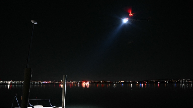
Around two dozen other crews had the same idea, and we lined up along the shoreline. Overhead police and coastguard helicopters swept low overhead, their searchlights piercing the gloom.

It may have been a clear night - we could see the stars, and felt the cold as well - but over the fairly wide expanse of water that is the Potomac at this point in its travels towards the sea, the city lights seem to make no difference: it was dark.
And did I mention the cold? Driving along the riverside near Arlington I could see fractured icesheets covering most of the river. Certainly not thick enough to skate on, but ice all the same.
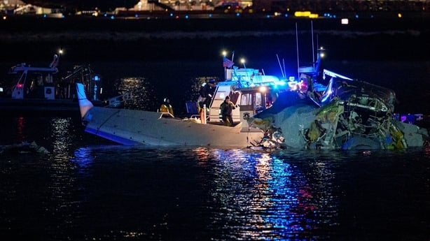
The crash site was not as troubled by the ice - faster moving current saw to that. But 5C is not far off freezing, and there were people in the water.
The living ones were the police, fire and state trooper diving teams who were slipping over the side of small boats to search the wreckage. Not only was it cold and very dark, but the wind was brisk out on the water, making their work harder.
The plane was in three parts, in water that we were told this morning was waist deep. The Sikorsky Blackhawk helicopter was floating upside down.
We could see neither from our vantage point, just the cluster of flashing lights from emergency vehicles on land and water that were working intensely to rescue survivors.
Because in those first couple of hours the emergency services worked with hope: hope they might find people alive in the water, racing against time and hypothermia.
After a couple of hours, we left the scene to begin editing and filing. The way back was a lot easier but it did bring us inside the airport perimeter. A place I have only know as a busy hub, comparable to a big, busy railway station, was now eerily quiet.
Audio captures moments before and after US air collision
At Gravelly Point, a car park at the north end of the runway where crews often go to get great takeoff shots of aircraft, the entrance was blocked, a few buses and three police cars all that occupied the land.
On the other side of the fence, planes lined up for a morning commute that wasn't going to happen.
Reagan Airport reminds me of a bigger, busier version of London City airport. They are both right beside the river that flows through their respective capital cities, the landing and takeoff routes take the planes right through the heart of the cities.
And the landing field and ramps are tight. They remind me of an aircraft carrier: tightly packed planes side by side, and a constant flow of landings and take-offs, a constant queue for each.
We were back in the office by 2am, just in time to go live on Morning Ireland.
By dawns light the emergency operation had pivoted to a recovery: time had run out for hope.
The combined airspeed of the impact was around 500km per hour. Altitude was low - about 130 metres. Normally the plane would be 15 seconds away from landing at Reagan National.
I've done the landing dozens of times. But this time a helicopter smashed into the Bombardier jet, and sent both aircraft into the Potomac, just offshore Joint Base Anacostia-Bolling, a military base area that houses the US Naval Research Centre, its roof festooned with white radomes protecting high tech Communications gear.
DC is one of the most militarised places in the whole US, with numerous forts, bases, military colleges, headquarters, research centres, garrisons and weapons dumps.
And of course there is the Pentagon, what seems like a stones throw from the north end of the runway at DCA.
These various military sites are often connected by helicopter flights: generals, admirals, grunts and packages moving between them constantly. And then there is the Marine One flight, the helicopters that ferry the President himself around.
The helicopters fly low here - usually 200 feet - about 60 metres above the ground, sometimes lower. This is to keep them away from the airport traffic.
And its not just military helicopters: the very active DC metropolitan police air wing fly their choppers low at all hours of the day and night, the heavy beating blades of their "Huey" type copters sounding like a Vietnam war movie.
The high altitude Belfast surveillance helicopters (or Garda air wing) it definitely ain't.
The Potomac river is the big visual guide and main highway for aircraft movements here. The north south approach to DCA for the jets (the low pass over the tower blocks of Rosslyn, on the Virginia side opposite Georgetown is never dull - unless you live there), and a regular route for helicopters. All supposedly under the control of the tower at DCA.
And indeed we now have the audio to prove it: all parties were in communications with the tower, the army chopper had visual contact with a passenger jet.
So why the crash? Even within the first half hour of this incident, that was the question most wanted answered.
Given where this happened, the involvement of the military, the proximity to the Pentagon, and the White House and its current resident, the answer may come sooner than usual.
I'm heading back to Dangerfield Island now. DCA is due to reopen to flights in a couple of hours. The recovery operation continues.


