The National Emergency Coordination Group has said that despite an expected improvement in weather conditions over the weekend, surface flooding persists and river flooding is still anticipated in some areas.
The group and its subgroups met following a night of heavy rainfall in the east, where 13 counties were under rainfall alerts which have now expired.
In a statement following the meeting, the NECG said that "surface flooding persists and river flooding is still anticipated in some areas today and tomorrow".
The group said that the situation will be monitored closely and agencies are ready to respond.
Another meeting will take place tomorrow to assess the situation and outlook, the NECG said.
The weather is expected to improve this weekend, with Met Éireann forecasting dry weather with scattered outbreaks of rain and drizzle.
Meanwhile, members of the public are being urged to drive with care and allow for disruption as response and clean-up operations are under way, following poor weather conditions overnight.
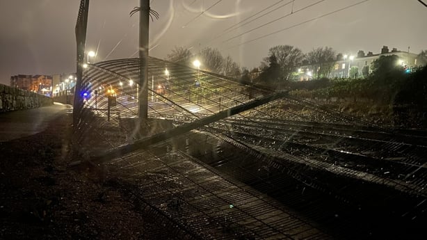
There are some delays to rail services in the east and motorists have been warned to take extra care on roads.
The southeast escaped the worst of the rainfall, but Wexford County Council is keeping a close eye on the River Slaney as rainfall over the Wicklow Mountains makes its way downstream in the coming days.
Watch: Drone footage shows the River Slaney rising in Bunclody, Co Wexford
The chief executive of Wexford County Council has said that the county has taken a "battering" and that flood plains are full, with significant damage caused to its road network due to the floods over the last ten days.
Eddie Taaffe said that while the River Slaney's levels rose again this morning, the river seems to have stabilised and that flows in the River Tullow have also reduced in the last number of hours.
"We are cautiously optimistic that the river levels in the Slaney, while they are high at the moment, will start to recede shortly and will recede over the weekend," Mr Taaffe said on RTÉ's Drivetime programme.
However, he said that council crews remain on alert and that temporary flood defence systems were built yesterday.
"We are cautiously optimistic that levels will start to drop," he said.
A wall of sandbags has been erected on the riverbank in Enniscorthy to prevent further flooding in the town, which experienced some of the worst effects of Storm Chandra last week.
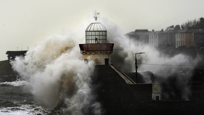
Watch: Wave overtopping in coastal areas of Co Dublin
The National Director of the National Directorate for Fire and Emergency Management has urged people to be careful on roads.
"If you come across flooded water, turn back, do not drive into it," Keith Leonard said on RTÉ's Morning Ireland.
"Unfortunately, every day this week we've had to rescue people from trapped cars and they're dangerous, and causes a lot of stress for people when that happens."
He explained that rainfall last night over Dublin and the Wicklow Mountains, will flow over the next 24 to 48 hours into Wexford, south Dublin and Kildare.
"We're on full alert really right throughout the weekend. As I say, the rainfall will be much lower over the weekend, thankfully," he said.
More: Follow live updates as they happen
Iarnród Éireann has said that all services operating on the DART, Northern Commuter, Rosslare and Enterprise Networks are operating.
It said that some of its services are facing delays of around 35 minutes due to poor weather conditions.
Delivery of flood relief schemes 'too slow', says minister
Minister for Public Expenditure Jack Chambers has acknowledged the delivery of flood relief schemes has been "too slow", and said that a "paralysis from the culture of judicial reviews" is impacting the progression of some relief schemes.
Speaking on RTÉ's Today with David McCullagh programme, Mr Chambers said he accepted that people in towns impacted by flooding were rightly frustrated at delays to such schemes.
"This comes back to wider infrastructure in the economy. The risk of judicial reviews is a major issue. I think that paralysis that feeds from the culture of judicial reviews is impacting the progression of certain flood relief schemes," he said.
We need your consent to load this rte-player contentWe use rte-player to manage extra content that can set cookies on your device and collect data about your activity. Please review their details and accept them to load the content.Manage Preferences
"Secondly, they are complex environmental and engineering projects which take time."
Asked whether locals who have objected to the implementation of flood relief schemes should be compensated for flooding, Mr Chambers said there "needed to be greater acceptance of infrastructure more generally" and that "people need to think twice about engaging in litigation when there is the level of risk in a local area".
"Secondly, when it comes to people's right to getting immediate support I don't think it's fair to connect the two, I think the State is there to support people in communities when an issue emerges."
Mr Chambers said most people in impacted communities didn't and don't object to such schemes, adding "it's a small minority who use very technical and procedural issues to block infrastructure and they have a right to do that".
"But I don't think the balance of rights isn't there in the Irish system right now and judicial reviews are bringing huge elements of risk aversion across the decision-making process."
"We need to rebalance rights," he added.