A number of Status Orange and Yellow weather warnings have been issued as very heavy rain is expected over much of the east and southeast of the country.
Status Orange warnings for rain have been issued for Dublin, Wicklow and Waterford, while Yellow warnings have been issued for nine other counties.
The first of the Status Orange warnings will come into effect at 9am for Waterford with Met Éireann warning of heavy rain falling on already saturated ground, which could cause localised flooding, river flooding and difficult travel conditions.
The warning will be in effect until 9am tomorrow.
The second Status Orange warning will be effect for Dublin and Wicklow from 12pm this afternoon until 12pm tomorrow.
Both counties are also subject to a Status Yellow warning for rain between 9am and 12pm.
Motorists in affected areas are being warned not to drive into flood water.
‼️Updates:
— Met Éireann (@MetEireann) February 5, 2026
🟠Status Orange Rainfall warning issued for Dublin, Valid 12:00 today until 12:00 06/02
➡️A Status Yellow Rainfall warning issued prior to Orange for Wicklow & Dublin, 09:00-12:00 today
➡️Timing updates issued to other warnings.
Visit: https://t.co/w5QtJ1V6un pic.twitter.com/QZAzzLsw87
Separately, a Status Yellow rain warning will be in place for Carlow, Kildare, Kilkenny, Laois, Wexford and Tipperary from 9am this morning until 9am tomorrow.
Cavan, Monaghan and Louth will also be under a Status Yellow rain warning from 12pm this afternoon until 12pm tomorrow.
In all cases, Met Éireann is warning that very heavy rain will fall on already saturated ground, which combined with high tides and high river levels, will lead to localised flooding, river flooding and difficult travelling conditions.
Wicklow County Council said that it is in "a state of readiness" ahead of the Orange warning.
In a social post, it said it has taken a number of preventative measures, including outdoor crews working to clear drains and gullies that have become blocked with flood debris; crews prepared and ready to respond to areas likely to be impacted by forecast high intensity rainfall; and stocks of sandbags have been replenished and available at depots across the county.
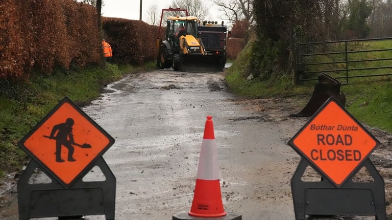
It added that roads subject to flooding and structural damage have been closed to traffic and that work continues to assess the scale of damage caused to the road network.
Waterford City and County Council are making sandbags available in some of their depots and are advising people to stay away from coastal areas.
Wexford County Council said roads are flooded in places where motorists might not ordinarily expect flooding.
The council has installed aqua dams along exposed parts of the quay in Wexford town ahead of high tide around 9am.
The council said that much of the spot flooding and pooling of surface water is caused by run-off from land, which combined with full drainage systems, will take time to recover.
High coastal levels will reduce the capacity for river discharge and increase flood risk in low-lying areas, especially at high tide, it said.
The council added that high spring tides for the remainder of the week, combined with strong winds and surge, may cause wave overtopping and coastal flooding in places.
Watch: Wexford County Council is preparing for 'very high tides' in Wexford harbour
Read more: Live: Updates as they happen
Met Éireann Meteorologist Michelle Dillon said that for an Orange warning over a 24-hour period, between 50mm and 80mm of rain has to fall "and up to double that on the windward side of mountains".
Speaking to RTÉ's Drivetime yesterday, Ms Dillon said coastal flooding is also a risk during the latest rain warnings because of high tides and "strong onshore winds" with easterly winds and "storm surge".
"We're looking at higher-than-usual spring tides, so at times of high tide we're looking at some coastal flooding too.