
Storm Bram caused flooding, travel disruption and left thousands of people without power as high winds and rain lashed Ireland.
Some 25,000 homes and businesses were still without power last night, predominantly in counties Cork, Tipperary, Wexford, Limerick and Kildare.
Winds reached 113km/h at Roches Point in Cork, and status Yellow wind warnings were in place for Donegal, Leitrim, Mayo, and Sligo until midnight.
Throughout the day, there were some incidents of flooding and fallen trees, particularly in the south of the country, where the storm first made landfall.
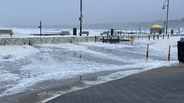
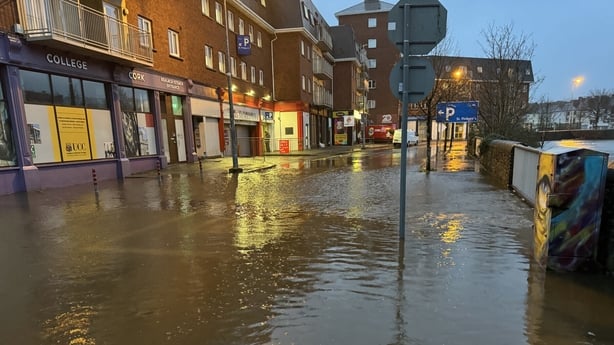
Dungarvan and Tramore in Co Waterford experienced some flooding as did Blackrock in Louth and the quays in Cork city at high tide, around 9am.
Services at Waterford train station were suspended for a time due to tidal flooding on the line but later resumed.
The Department of Education confirmed that while the vast majority of schools opened as scheduled, around 70 schools, predominantly located in coastal areas in the west of Ireland, decided to close.
DART services were suspended between Pearse and Dún Laoghaire for around three hours, after a train hit a fallen tree, which also caused damage to the overhead power lines.
Flooding on the line between Greystones and Wicklow also caused delays, but all Irish Rail services had been restored by 8.30pm.
A number of flights were cancelled at Dublin, Cork and Shannon airports while ferry sailings were also affected as Storm Bram hit.
Watch: Storm Bram brings flooding to Cork city
Met Éireann warned of the potential for flooding of low-lying coastal areas, especially during high tide as well as wave overtopping.
Over 100 flights cancelled at Dublin Airport
A spokesperson for Dublin Airport said more than 100 flights had been cancelled.
Media Relations Manager at daa Graeme McQueen said: "Storm Bram has had a significant impact on operations at Dublin Airport today, with more than 100 flights cancelled by airlines. A further 20 flights were diverted to other airports, although many have since returned - or are in the process of returning - to Dublin Airport.
"Challenging wind conditions made it impossible for aircraft to land and take-off at Dublin Airport for extended periods this afternoon.
"Winds have eased considerably since 7pm, which has allowed for flight operations to resume as normal once again.
"Dublin Airport expects to be fully open tomorrow morning for the busy first wave, however the potential is there for some disruption to airline schedules as a result of aircraft and crews being out of position.
"As always, passengers due to fly tonight and tomorrow should contact their airline directly for updates regarding the status of their flight."
Watch: Flooding and strong waves as Storm Bram hits Waterford
Shannon Airport confirmed that three flights were diverted there from other airports in the country due to adverse weather conditions caused by Storm Bram.
"These include Ryanair flight FR RK6SG from Manchester to Cork, which landed safely at 15:02; Aer Lingus flight EI 168 from Los Angeles to Dublin which arrived safely at 15:40; and Aer Lingus flight EI 952 travelling from Seattle to Dublin, which landed safely at 15.42."
A spokesperson for the airport said it was continuing to closely monitor weather conditions and advised passengers to check for updates with their airlines.
A number of ferry sailings were cancelled due to adverse weather conditions, with passengers advised to check with their ferry operator for the latest information and details regarding alternative sailings.


