
Met Éireann has upgraded Co Kerry to a Status Orange rain warning for tomorrow as Storm Amy is set to bring rain and strong winds in the coming days.
The first storm of the season is forecast to hit Ireland tomorrow at 6am.
The Status Orange rain warning for Kerry, which starts at 6am tomorrow and will last until 8pm tomorrow night, will bring heavy spells of rain, potentially leading to flooding and very difficult travelling conditions.
A Status Yellow rain warning has been issued for Cavan, Donegal, Munster, Connacht and Longford and will be in place from 6am tomorrow until 8pm.
While a separate Status Yellow wind warning is issued for the entire country Friday.
Met Éireann has warned of widespread rain which may lead to localised flooding, difficult travelling conditions and blocked drains.
On Friday, the entire country will be under a Status Yellow wind warning as Storm Amy brings strong to near gale force and gusty southwesterly winds, with the forecaster warning of difficult travelling conditions, debris and loose objects displaced and possibly fallen trees.
The UK Met Office also issued a weather warning for Antrim, Armagh, Down, Fermanagh, Tyrone and Derry, with strong winds leading to possible disruption during Friday evening and overnight into Saturday.
The Yellow warning for wind will be in place from 4pm on Friday until 6am on Saturday.
It also issued warnings for heavy rain in parts of western and southern Scotland over the next few days.
Met Éireann also issued a Status Yellow gale warning from Fair Head to Carlingford Lough to Carnsore Point and on the Irish Sea from 5pm tomorrow until midnight.
Update - Preceding #StormAmy⬇️
— Met Éireann (@MetEireann) October 1, 2025
⚠️Kerry has been updated to an Orange Rainfall warning⚠️
➡️Heavy spells of rain.🌧️
Potential impacts:
➡️Flooding expected.
➡️Very difficult driving conditions.
⏲️Valid: Tomorrow, Thursday 2nd Oct, 06:00 until 20:00. pic.twitter.com/HjSKRkSi9A
In a post on X, Met Éireann said updates will be issued as "certainty increases".
Speaking on RTÉ's Drivetime, Meteorologist with Met Éireann Michelle Dillon said that the latest updated weather warnings will be coming in advance of Storm Amy on Friday.
"Ahead of Amy, we have some very heavy, impactful rainfall tomorrow," she said.
"This Yellow rainfall warning has been issued for Munster, for Connacht, Cavan, Donegal and Longford and it's that warning has been upgraded to Orange for Co Kerry for tomorrow. That’s all happening in advance of Storm Amy."
Ms Dillon said the weather system was still a while away from hitting Ireland.
"This is still a long way away, over the other side of the Atlantic. But the Atlantic is very unsettled at the moment," she said.
"Conditions are ripe for this low pressure to rapidly deepen, develop, come across the Atlantic and continuing to deepen as it approaches ourselves and the UK."
Ms Dillon said that it was likely that the storm will mainly impact the northwest of the country before moving towards Scotland.
She added that there was no chance of Ireland avoiding the storm, and warned of a possibility of upgrading the warnings further.
"The storm track looks set to come some place in the vicinity," she said.
"It could shift further south, it could shift a little bit further north. If it shifts even further south, and we'll be watching that, there could be further upgrades to those wind warnings, especially in parts of the northwest and north."
"Storm Amy is more a wind event, but there will also be more heavy rain with it as well," she added.
Met Éireann said that based on current indications, the unsettled weather will continue into next week.
RSA advising road users to 'slow down' upon storm's arrival
The Road Safety Authority said road users "need to slow down" and allow a greater braking distance between themselves and the vehicle in front in wet weather conditions.
"This is especially important on high-speed roads such as dual carriageways and motorways where there is increased danger of aquaplaning," it said.
It advised road users to take special care when driving behind goods vehicles, as they generate a considerable amount of spray, which reduces your visibility.
"Hold back to where you can see their mirrors," the RSA advised.
In the event of road flooding, motorists are being advised to choose another route.
"Do not attempt to drive through it. Flooded roads that appear shallow could be deeper than you think.
"The verge may have subsided and there may also be trees or branches that have fallen that may not be visible," the authority added.
Road users are also being advised to follow recommended routes and obey signs closing roads to traffic that have been put there by the local council or An Garda Síochána.
"After going through water, drive slowly with your foot on the brake pedal for a short distance - this helps to dry the brakes," the RSA said.
"Drivers should allow extra space between themselves and vulnerable road users such as cyclists and motorcyclists as they may be blown off course by strong winds."
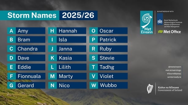
Amy is the first named storm of the new season which began on 1 September and runs until 31 August next year.
The list is released by Met Éireann along with the national weather services of the UK and the Netherlands.
The seven names chosen by Met Éireann are: Bram, Fionnuala, Gerard, Kasia, Marty, Patrick and Tadhg. The UK Met Office named Storm Amy earlier this morning.
⚠️#StormAmy has been named by the UK Met Office.⚠️
— Met Éireann (@MetEireann) October 1, 2025
➡️This will bring heavy rainfall tomorrow with strong winds expected on Friday. A number of warnings will be issued today, with updates as certainty increases.
ℹ️Stay updated at: https://t.co/w5QtJ1V6un pic.twitter.com/PRk3RfoRDW
Additional reporting PA