President Ferdinand Marcos Jr ordered the Philippines disaster response agency to go on full alert and mobilise all government agencies as Super Typhoon Ragasa threatened the north of the country and set off storm alerts across East and Southeast Asia.
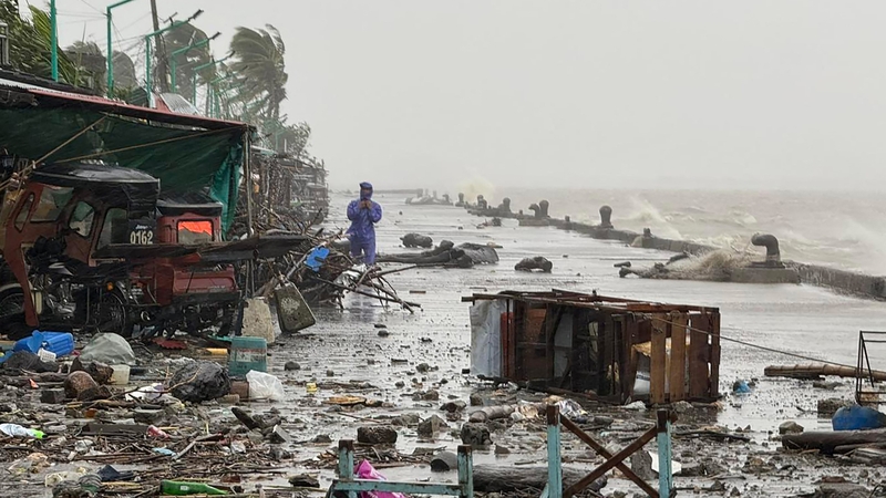
Packing winds of 215km/h and gusts of up to 295km/h, Ragasa made landfall in Calayan Island in Cagayan province, raising the risk of storm surges exceeding three metres, the state weather agency said.
The Babuyan islands remained under a high-level storm warning signal, with residents advised to stay away from coastal areas and riverbanks.
Video clips shared by disaster agencies showed the northern Cagayan province being pummelled by fierce winds and heavy rain, triggering strong waves and sending trees swaying violently.
The government suspended work and classes across Metro Manila and large parts of Luzon as outer rainbands began lashing the region, prompting warnings of power outages, landslides, floods, and dangerous seas.
Airlines have cancelled two dozen domestic flights, mostly serving Luzon's main hubs, while ports have suspended ferry services.
The Philippines is the first major landmass facing the Pacific cyclone belt, and the archipelago is hit by an average of 20 storms and typhoons each year, putting millions of people in disaster-prone areas in a state of constant poverty.
Scientists warn that storms are becoming more powerful as the world warms due to the effects of human-driven climate change.
Although Ragasa will not directly hit Taiwan, its outer bands are expected to bring heavy rain to the island's sparsely populated east coast. Taiwan has issued land and sea warnings, cancelled 146 domestic flights, and evacuated more than 900 people from mountainous southern and eastern areas.
Vietnam's defence ministry has ordered its forces to monitor the storm and prepare for a possible landfall later this week. Chinese authorities have activated flood control measures in several southern provinces, warning of heavy rain beginning tomorrow night.
Hong Kong said its airport will remain open, but operations will be scaled down. Yeung Tat-wing, director of service delivery at the Hong Kong Airport Authority, said flight operations would be significantly reduced after 6pm local time (10am Irish time) on Tuesday, and most flights will be affected on Wednesday.

Cathay Pacific said it will cancel about 500 flights. Macau and Zhuhai are also bracing for impact, with school closures and evacuation plans under way.
In Hong Kong, residents started stockpiling daily necessities on Monday morning. Long queues formed at supermarkets where products like milk had already sold out, while vegetables were being sold for more than triple their normal price at fresh markets, according to Reuters witnesses.
Chinese city to evacuate 400,000 ahead of super typhoon
China is to evacuate 400,000 people from the city of Shenzhen ahead of an incoming super typhoon, authorities have said.
"The city plans to relocate and resettle approximately 400,000 people, including those residing in temporary shelters, low-lying areas, and coastal regions," a post on Shenzhen's Emergency Management WeChat account said.
It comes as more than 10,000 evacuees sheltered in schools and evacuation centres in the Philippines as heavy rains and gale-force winds from Super Typhoon Ragasa lashed the country's far north.
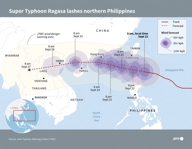
The typhoon, which is gaining strength as it proceeds on a collision course with southern China, was expected to make landfall over the Philippines' Babuyan Islands around midday.
The sparsely populated islands lie about 740km/h south of Taiwan, where smaller-scale evacuations were also underway.
As of 11am local time (4am Irish time), maximum sustained winds of 215km/h were reported at the storm's center, with gusts reaching up to 265km/h as it moved westward towards the Babuyans, the national weather service said.
Cagayan disaster chief Rueli Rapsing said that his team was prepared for "the worst".