
A big storm, named Floris by the UK Met Office, is heading our way over the coming days.
It is likely to bring unseasonably strong winds, heavy rain and cause considerable disruption, especially to the north west of the country and to Northern Ireland.
The storm, which is predicted to be exceptionally strong especially for this time of year, will arrive tomorrow night and be at its height by Monday morning.
As a result, Met Éireann issued Status Yellow weather warnings ahead of its arrival.
The forecaster warned that more people than usual are likely to be exposed and impacted due to a large number of outdoor events taking place, as well as people camping, holidaying and engaging in outdoor pursuits at this time of the year.
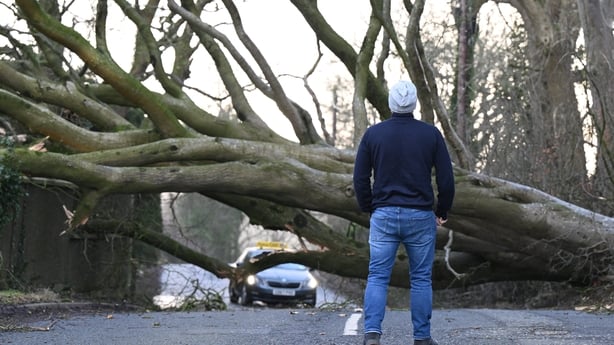
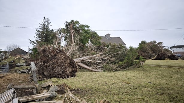
There are fears too that a storm of this magnitude could do huge damage to trees that are full of leaves at the height of the summer.
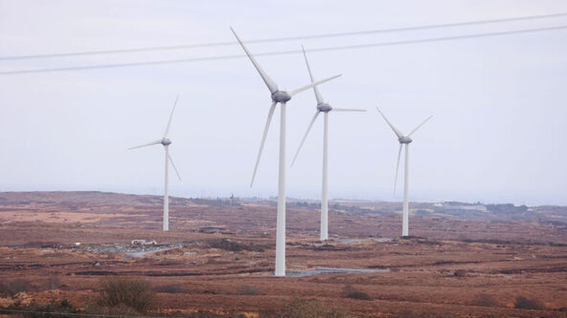
And of course, damage to trees in Ireland inevitably means damage to electricity poles, power outages, and local disruption to the electricity supply network.
Met Éireann is highlighting other potential hazards too.
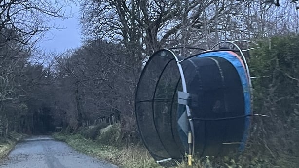
It is warning of dangerous driving conditions, fallen trees, debris and loose objects, structural damage, wave overtopping and localised flooding that will be made worse by leaves and debris.
Forecaster Andrew Doran-Sherlock said as it is a Public Holiday weekend more people will be at a greater risk of exposure than would normally be the case.
He said: "While we are in a period of neap tides, with lowest tidal ranges of this cycle expected on Sunday and Monday, strong onshore winds and high waves may cause wave overtopping in low-lying coastal areas in the northwest and west.
"Our advice would be to pay attention to the weather forecasts and warnings issued over the weekend and take them into consideration with any plans you have.
"And as always, please heed the advice of local authorities."
There is still some uncertainty in the details so the full impact of the storm system cannot be determined.
Nevertheless, on Friday, forecasters at the British Met Office were not ruling out the possibility that Storm Floris could bring with it an unusual phenomenon that weather professionals refer to as "explosive cyclogenesis".
In common, or tabloid, parlance that means Storm Floris could turn out to be a so-called "weather-bomb".
This occurs when a storm brings a rapid drop in air pressure of 24 millibars, or more, in 24 hours.
It is a rare phenomenon in an Irish context, but when it does happen wind speeds tend to become extremely intense.
That is exactly what occurred during the devastating Storm Éowyn last January, the costliest storm in terms of damages to ever hit the country.
Floris could qualify as a 'weather bomb'
Meteorologists at the UK Met Office said yesterday that although it is difficult to be sure, it looks like air pressure will be about 1,005 hectopascals 24 hours before the storm, but will fall as low as 980 hectopascals and maybe even lower when it arrives.
If that does happen then Storm Floris would qualify as a "weather bomb" and the winds at the centre of the storm would be extremely strong.
Of course, that does not mean this storm will be as damaging as Storm Éowyn because the timing, the trajectory and the position of the coming storm when it is at its maximum will be different.
Éowyn was a direct hit on the coast of Ireland while Floris is currently expected to track to the northwest of the country, so its impact is unlikely to be as fierce.
Nevertheless, it would be truly remarkable if two storms characterised by "explosive cyclogenesis" impacted Ireland in a period of less than seven months.
The meteorologists at the UK Met Office are saying this cannot be ruled out so it is well worth watching out for.
One can expect to hear a lot of discussion about the fingerprints of climate change if that does turn out to be the case.
As things stand right now, the UK Met Office is predicting potentially record gusts for this time of the year, of up to 100km/h or more in the northwest of Ireland and Northern Ireland early on Monday.
There is no question that will come as a shock to many holiday makers.
It is a big nuisance for farmers and crop growers too.
Five years ago this month, when Storm Francis hit, some of Ireland’s apple growers lost as much as 30% of their crops due to wind damage.
Rivers burst their banks, with people needing to be rescued from up to 300 homes in Newcastle, Co Down.
This month two years ago Storm Betty caused flooding, fallen trees, branches and debris across the south of the country, with electricity outages affecting 70,000 homes, farms, and businesses.
The stories were similar and the experiences equally challenging during Antoni, Lillian, Ellen and Evert - the four other August named storms during the eleven years since the convention of naming storms was adopted here.
On that basis, expect lots of reminders and very good advice about taking care, avoiding hazards and driving carefully over the coming days.
The good news on the weather front is that the UK meteorologists are expecting that after the storm weather will settle down quickly and we should be back to calm and warm conditions by Wednesday with high pressure ruling the roost.


