Storm Kathleen, which will hit Ireland tomorrow, will bring "very severe winds" in the five counties under Status Orange wind warnings, the National Director for Fire and Emergency Management has said.
Cork, Kerry, Waterford, Galway and Mayo will see the strongest of the winds, with Keith Leonard describing the storm as "dynamic".
Two Status Orange wind warnings have been issued.
Cork, Kerry and Waterford will be under an Orange wind warning from 7am until 2pm, while another Status Orange warning for wind will be in effect for Galway and Mayo from 9am until 6pm.
Speaking on RTÉ's News at One, Mr Leonard said it is a "bit late" in the season for a named storm and people might be caught "unawares".
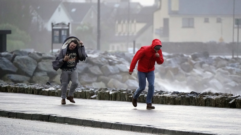
He said the "key safety message" is to "stay away from coastal areas across the country tomorrow."
Mr Leonard said conditions would be "difficult" everywhere, particularly in coastal areas, and warned of difficult road conditions, with fallen trees, and debris.
Met Éireann said Storm Kathleen will bring gale force southerly winds, with some severe and damaging gusts and could cause difficult travelling conditions, fallen trees and power outages.
"We're in this period of spring tides too, so we're going to see some coastal flooding, some wave overtopping so very treacherous conditions, particularly on those exposed coasts," Met Éireann meteorologist Mark Bowe said.
All of Ireland will be under a Status Yellow wind warning from 5am to 8pm.
Status Yellow - Wind warning for Ireland⚠️🌬️
— Met Éireann (@MetEireann) April 5, 2024
Possible impacts:
Some fallen trees
Difficult travel conditions
Debris, loose objects displaced
Coastal flooding
Wave overtopping
Valid: 05:00 Saturday to 20:00 Saturday 06/04/2024 pic.twitter.com/FvqNvhnB0L
Met Éireann forecaster Joanna Donnelly said Storm Kathleen is "moving and changing" which is why it has been described as "dynamic."
Speaking on Drivetime, Ms Donnelly said Storm Kathleen is a "wind event" and that rain is not the "significant feature" as the heaviest rain associated with the storm is out in the Atlantic Ocean.
She said there was a "rapid deepening" of the low pressure associated with the storm early today and there will be another rapid deepening overnight tonight, which is what brings the very strong winds and when Irish coasts will begin to feel the biggest effect.
Ms Donnelly said the storm is not moving northwards that rapidly so it will be windy all day Saturday and will still be windy on Sunday.
She added that heavy rain will follow the storm on Monday and there is no sign of any settled weather next week.
We need your consent to load this rte-player contentWe use rte-player to manage extra content that can set cookies on your device and collect data about your activity. Please review their details and accept them to load the content.Manage Preferences
The UK Met Office has issued a Yellow wind warning for Antrim, Armagh, Down, Fermanagh, Tyrone and Derry, which will be in operation from 8am until 10pm.
Minister of State with responsibility for Office of Public Works, Patrick O'Donovan, said the five counties subject to the Status Orange warning are now "adept" at mobilising crews, together with utility companies, ESB and Irish Water, in the wake of ten named storms already this storm season.
Mr O'Donovan - who this morning attended a briefing by Met Éireann at the National Directorate for Fire and Emergency Management (NDFEM) ahead of Storm Kathleen – said the main issue will be wave overtopping in coastal areas due to high Spring tides and rising river levels inland and in rural areas.
He said this is the last thing the farming community and those threatened with coastal flooding want to hear, and it is a worry.
Mr O'Donovan said local authorities "know the key areas where there is the greatest level of risk".
He advised people particularly in coastal areas to "stay back, to stay high and to stay dry".
Road users urged to take care
The Road Safety Authority has asked all road users to exercise caution while using the roads while the weather warnings are in effect.
People in or travelling to areas affected by the Orange warning are advised to check local traffic and weather conditions before setting out on their journey.
Drivers are reminded to allow extra space between vulnerable road users such as cyclists and pedestrians and also to increase braking distance when driving behind other vehicles.
Particular care is urged when driving high-sided vehicles that may be blown off course by strong winds.
Meanwhile, cyclists and pedestrians are encouraged to ensure that they are visible to other road users.
Eleventh named storm of season
Storm Kathleen, which was named by Met Éireann, will be the 11th named storm in the 2023-2024 storm season.
Storm seasons run from the start of September to the end of the following August.
The last storm season saw four named storms hit the country. No storm season has ever got beyond the letter K.
The last named storm to hit Ireland was Jocelyn, which struck on 23 January. That was preceded by Storm Isha, which brought gusts of 137km/h during its peak on 21 January.