

Analysis: A sudden stratospheric warming is when rapid warming occurs in the stratosphere, which can have a massive impact on our weather
You don't need to be a weatherman or to read this article to know that Ireland has had a lousy winter with lots (and lots) of rain and grey skies. The meteorological spring begins on Sunday (1 March), but climatologists and weather forecasters are still keeping their eyes firmly on the stratospheric polar vortex, with a split-type sudden stratospheric warming occuring in the early days of the coming month. We have heard these terms before so we've asked Met Éireann climatologist Paul Moore to explain what all of this will mean for your weather forecast.
Remind us: what is the stratospheric polar vortex?
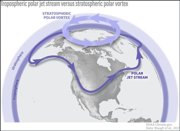
The stratospheric polar vortex (SPV) is a natural, annual atmospheric phenomenon that occurs in the stratosphere over Polar regions in both hemispheres during their respective winters. It is initiated when the sunshine reaching the Polar stratosphere decreases, intensifying the temperature gradient between the cold polar stratosphere and tropical stratosphere.
During the Northern Hemisphere winter, this increasing temperature gradient creates a core of intense westerly winds circumnavigating the North Pole high up in the stratosphere centred at around 60°N, sometimes referred to as the Polar Night Jet. The SPV, which strengthens during the autumn months as the temperature gradient increases, is usually at its strongest through the winter months, and separates the very cold air over the Arctic in the stratosphere and the warmer air further south.
The SPV naturally breaks down every spring, on average in mid-April, when sunlight returns to the Polar regions, warming the atmosphere and decreasing the temperature gradient. The SPV can also weaken or break down during the winter months through dynamical processes, usually caused by atmospheric wave breaking in the troposphere sending energy up into the stratosphere, raising the temperatures and disrupting the flow. A total breakdown of the SPV where the westerly winds reverse to easterly is called sudden stratospheric warming (SSW). More on this later.
The standard way of measuring the strength of the SPV is by monitoring the zonal mean zonal wind (ZW) at 60°N and at 10 hPa (about 30km high). The zonal mean zonal wind is the wind at a particular point in height and latitude averaged around the whole hemisphere.
How does the stratospheric polar vortex influence the jet stream?
To a large extent, the North Atlantic jet stream (or Polar Jet Stream) controls the type of weather we experience on a day to day basis in northwest Europe. It is much lower down at the top of the troposphere and can be strongly influenced by what is happening high above it in the stratosphere during winter.
We need your consent to load this rte-player contentWe use rte-player to manage extra content that can set cookies on your device and collect data about your activity. Please review their details and accept them to load the content.Manage Preferences
From RTÉ's Hot Mess podcast, has the Jet Stream, the key shaper of Ireland's weather, been knocked off course by climate change?
When the SPV is strong and stable, it can add westerly momentum to the North Atlantic jet stream, keeping it further north and more zonal (west to east), sometimes contributing to an active storm season for northwest Europe. But when the SPV is weakened, it can lead to a south-shifted North Atlantic jet stream in winter with higher-than-normal pressure at the surface over Polar regions, much like what has happened this winter so far. Sometimes, there can be a disconnect between the stratosphere and troposphere where they both do their own thing and don't interact much at all.
You mentioned a sudden stratospheric warming
When the SPV breaks down completely during the winter months in a dynamical way, through tropospheric wave breaking sending energy up into the stratosphere, and the zonal wind at 60°N and at 10 hPa (about 30km high) reverse from westerly to easterly, along with a sudden spike in stratospheric temperatures in Polar regions, it is called a Sudden Stratospheric Warming (SSW). Reversing the winds from westerly to easterly high up in the stratosphere causes major disruption to the flow beneath and the easterlies usually start descending through the atmosphere towards the troposphere, which can take up to two weeks.
When the easterly flow reaches the top of the troposphere it can sometimes, but not always, lead to a more abrupt shift in the large-scale tropospheric patterns for the mid-latitudes. It can initiate a weakening in the North Atlantic jet stream, which begins to meander from north to south, creating blocking high pressure systems. At the surface, cold air is forced southwards into the mid-latitudes and warm air is drawn up into the Arctic. The influence of the breakdown of the SPV on the troposphere can last for two to three months.
We need your consent to load this rte-player contentWe use rte-player to manage extra content that can set cookies on your device and collect data about your activity. Please review their details and accept them to load the content.Manage Preferences
From RTÉ Radio 1's Morning Ireland, Met Éireann climatologist Paul Moore on the weather in Ireland in 2026 so far
A SSW can usually take two forms: a displacement of the SPV away from the North Pole (which then weakens because it has moved away from its power source), or a split in the SPV into two separate cores that are pushed away from the North Pole in different directions. For northwest Europe, a split type SSW is more likely to lead to dramatic weather pattern shifts compared to a displacement type SSW.
So what has been happening with the stratospheric polar vortex this year?
The chart below plot shows the strength of the zonal wind at 60°N and at 10 hPa. The thick black line is the climatological average strength through the year and the thin black lines at the top and bottom are the record high and low strengths for each day through the year.
The blue line shows the strength of the ZW at 60°N and at 10 hPa during 2024/2025 and the red and pink line show 2025/2026 so far along with the forecast strength over the next week (orange line). Above the horizontal purple line represents westerly winds and below the purple line is easterly winds. As I mentioned above, easterly winds occur during a SSW or after the final warming in spring and last through the summer months.
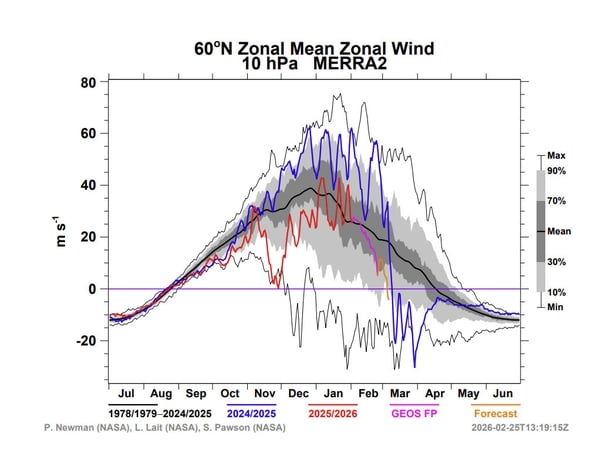
Looking at the blue line first you can see that the SPV during the 2024/25 winter was generally stronger than average (above the black line) but then went through an early final warming or breakdown on 9th March 2025. This contributed to a weakening of the North Atlantic jet stream during spring in 2025.
This winter (red into pink line) the SPV has been much weaker overall and went through a displacement SSW (or very close to one) in late November. This very early SSW and subsequent weak SPV through the winter contributed to higher than normal pressure at the surface in the Arctic and a southern shifted jet stream in the North Atlantic. This in turn led to sustained cold outbreaks over northern Europe and North America. Subsequently, the cold block over northern Europe along with the south shifted jet stream has resulted in a lot of rain for the south and east of Ireland during January and February this winter.
Are we going to see a sudden stratospheric warming?
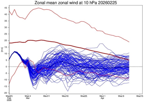
The forecast above for the ZW at 60°N and at 10 hPa (orange line) shows that a SSW is now forecast over the next week to 10 days. But this SSW is likely to be a split type SSW. To understand the difference, let's look at another type of chart. The ECMWF charts below are showing the geopotential height at 10 hPa looking down from above with the North Pole in the centre.
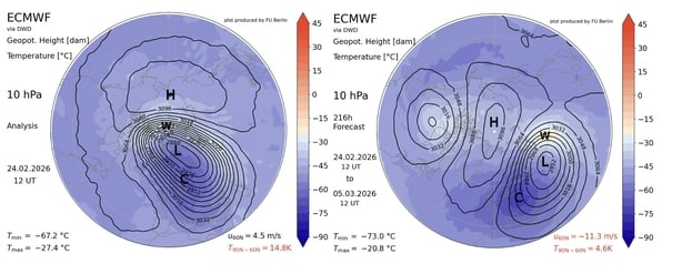
The first chart is an analysis chart from Tuesday 24th February 2026. It shows an already weakened SPV (the centre of which has an L symbol for low pressure) displaced away from the North Pole. The strength of the ZW at 60°N and at 10 hPa is 4.5 m/s (depicted as U60N). This is already well below average for late February, as can be seen in the chart above (end of pink line).
The second chart above shows the forecast for the ZW at 60°N and at 10 hPa on Thursday 5th March 2026. The SPV has split into two cores, with one centred over North America and the other centred over Aisa and a high pressure in between. The ZW at 60°N and at 10 hPa has dropped to -11.3 m/s, which as I explained above is easterly and a split type SSW has occurred. This forecast has been consistent for several days now and other global models are showing something similar, so we can have confidence in this forecast now.
What does all this mean for us weather-wise in early March?
Even though we can now have confidence that a split-type SSW will occur in early March, how that influences our weather in northwest Europe is still very uncertain. The global weather patterns at any given time depend on numerous global drivers and how they interact with each other in a highly complex and chaotic way. What we can say is this upcoming split type SSW increases the likelihood of a change in the weather patterns with more high and mid-latitude blocking from sometime around mid-March.
In the past, SSWs have sometimes had major influences on our weather; for example, the Beast From The East and Storm Emma in February/March 2018 when the easterlies from the stratosphere penetrated all the way to the surface. On other occasions when a SSW occurred, the easterlies didn't penetrate into the troposphere and there was little or no influence on our weather, like in early 2019.
Bear in mind that if the easterlies do penetrate to the surface in March, our day to day weather depends of where the blocking high pressure systems set up and whether its turns out to be the final warming, like last year, or a SSW where the westerlies recover, as shown in the ECMWF forecast above.
Follow RTÉ Brainstorm on WhatsApp and Instagram for more stories and updates
The views expressed here are those of the author and do not represent or reflect the views of RTÉ