
Analysis: Long tailbacks, sitting in traffic and navigating the M50 are a fact of life for many in Dublin. But how did the city become so jam-packed with cars?
By Katie Blackwood, Dublin City Historian in Residence
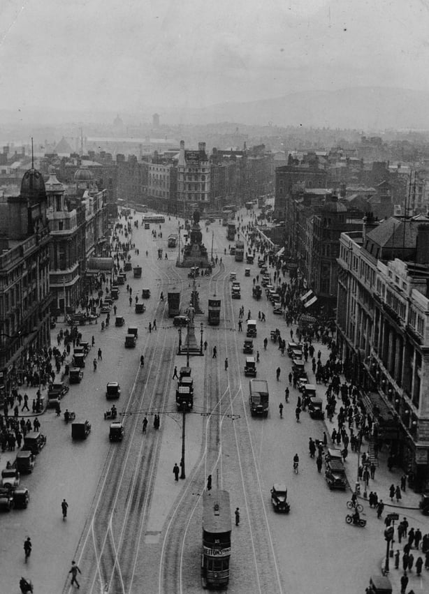
The twentieth century saw the transformation of Dublin into a motorised space that radically changed how people experience the city. Today there is one car for every two people living in Dublin. Long tailbacks, sitting in traffic and navigating the M50 are a fact of life for many citizens. But how did Dublin become so jam-packed with cars and how does their presence affect the city?
Automobiles first appeared on the streets of Dublin in 1896. As elsewhere, the first cars were playthings for the wealthy attracted by the promise of speed and adventure. From the outset, cars were a potent symbol of modernity, in which the machine was a metaphor for progress. They quickly proved to be immensely popular.
Within a couple of decades motor vehicles had replaced horses as the dominant form of transport and haulage in Dublin. However, new infrastructure and legislation were required to accommodate the car. The stone setts (cobblestones) and water-based macadam surfaces of Dublin's roads needed constant repair due to the weight and speed of cars. So, the streets were repaved in more durable tar asphalt. Designated parking spaces and a series of one-way streets were introduced. There was a brief controversy over kerbside petrol pumps obstructing footpaths. Road signs, too, were standardised and installed.
1937 saw Dublin’s first set of traffic lights at the junction of Clare Street and Merrion Square. Reports stated that "there was considerable confusion at first" with drivers uncertain of the correct protocols. Many stopped their cars as soon as the light turned red, rather than continuing up to the junction.
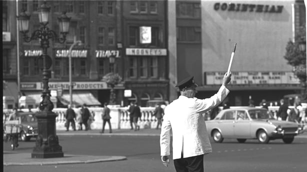
By the 1950s there were 48 junctions controlled by traffic lights in the city-centre, although gardaí continued to manually control the more complex intersections. Since then, traffic lights and other road features such as roundabouts, junction boxes, cycles lanes, and pedestrian crossings have become ubiquitous on Dublin’s streets. Along with footpaths, they determine how drivers, cyclists and pedestrians move through the urban space.
As cars became more commonplace, traffic and obstructive parking became an issue of public concern. Several bridges were constructed over the Liffey to ease traffic bottlenecks. The first of these was the Matt Talbot Bridge in 1978, followed by Frank Sherwin Bridge at Heuston Station in 1982. Once these two bridges were in operation, Dublin Corporation changed the direction of traffic on the quays to improve the flow of traffic. In 1970 parking meters were installed on the streets and multi-storey car parks opened, forcing drivers to pay for parking. This was followed by the clamping of illegally parked cars since 1998. The sheer amount of space required by cars in the city required penalties and policing.
Writing in 1957, Roland Barthes commented on the cultural significance of the car calling it "the supreme creation of an era, conceived with passion by unknown artists, and consumed in image if not in usage by a whole population which appropriates them as a purely magical object."
We need your consent to load this rte-player contentWe use rte-player to manage extra content that can set cookies on your device and collect data about your activity. Please review their details and accept them to load the content.Manage Preferences
From RTÉ Archives, A new traffic flow system is introduced in Dublin in 1982 involving a one-way reversal along many streets and the quays
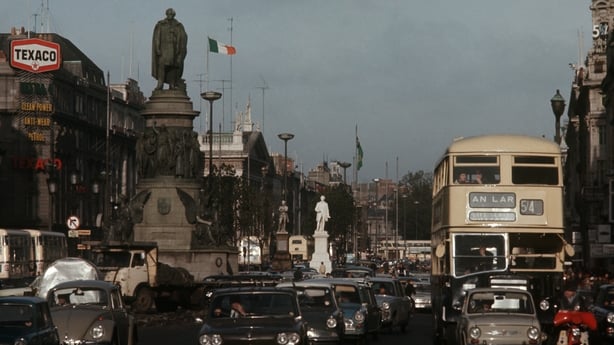
Certainly, Dubliners were enthralled to the car and eagerly embraced the era of mass motorisation. A survey of traffic flow in Dublin’s city centre taken in 1961, and repeated in 1971, found that the number of bicycle journeys in Dublin had dropped by a massive 80% and were replaced by car journeys. Bicycles were associated with poverty whereas cars symbolised freedom and success. Car ownership also affected leisure pursuits with more access to the countryside. Roadside picnics and going for a drive in the Dublin mountains became popular pastimes for city dwellers.

Over the twentieth century vast swathes of Dublin’s population moved out of the inner city to newly built suburbs in areas like Cabra, Crumlin, Ballyfermot and Finglas. This extended to the new towns of Blanchardstown, Clondalkin and Tallaght in the 1970s. Cars became a practical solution to a longer commute where public transport was unreliable. By the 1970s, 48% of all households had a car. Driveways and garages became a feature of new housing developments. 'The Safe Cross Code’ song was taught to children to instil good road crossing habits. While the perceived dangers of traffic meant that Dublin's children were increasingly travelling to school by car.
Read more: Is it time to take different approaches to road safety?
In 1939 there were 44 road deaths and 1,648 injuries in the Dublin Metropolitan area. According to press reports, inebriated drivers and careless pedestrians were often to blame. Road deaths peaked in 1978. Measures such as breathalyser testing, drink driving limits, and mandatory seat belts aimed to tackle this.
The 1960s and 1970s saw Dublin Corporation commission several traffic plans to solve the congestion in the city. These plans proposed motorways as a solution over infrastructure for public transport, cycling or walking. For example, The Dublin Region, a report by Myles Wright published in 1967, was heavily car focused. It recommended a new "road superstructure in a grid pattern" around Dublin. Although many aspects of these plans went realised, the M50 motorway was eventually built between 1988 – 2005.
We need your consent to load this rte-player contentWe use rte-player to manage extra content that can set cookies on your device and collect data about your activity. Please review their details and accept them to load the content.Manage Preferences
From RTÉ's Thomas Davis Lectures, Geographer Dr Ruth McManus, lecturer at Dublin City University, looks at the urban areas we create
In recent years an 'edge city’ has emerged where shopping centres, business parks and entertainment such as cinemas are often located off the M50. Many of these places are only accessible by car. Meanwhile the city centre continues to grapple with how to organise urban space. There is a growing movement to remove the car from the city, to create pedestrianised streets, and to improve public transport and cycle infrastructure. Dublin’s twentieth century urban planning was dominated by the car. Time will tell how it will cope with this challenge in twenty first century.
Katie Blackwood is a Historian in Residence with Dublin City Council.
Follow RTÉ Brainstorm on WhatsApp and Instagram for more stories and updates
The views expressed here are those of the author and do not represent or reflect the views of RTÉ