

Analysis: The reduction in water levels in Poulaphuca shows the link between reservoirs, river water flows and rainfall
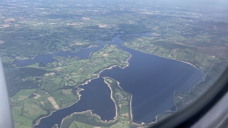
I arrived back in Ireland last weekend after a summer break abroad and was treated to a flight path over the Wicklow mountains on the approach into Dublin airport. I was struck by the sight of the Blessington lakes beneath and what seemed like beautiful sandy beaches lined the edges of the lake. In fact, what I was looking at was evidence for very low water levels within the largest reservoir which provides drinking water for the greater Dublin area.
In a country which traditionally has had an image of having an abundance of rainfall, why is it that we are seeing repeated hosepipe bans during summer time in Ireland? Why are we seeing reductions in the water pressure in our kitchen taps when these are fed from the mains?
We need your consent to load this rte-player contentWe use rte-player to manage extra content that can set cookies on your device and collect data about your activity. Please review their details and accept them to load the content.Manage Preferences
From RTÉ Archives, Brendan O'Brien reports for RTÉ News in 1978 on the re-emergence of St Brendan's holy well in Co Wicklow for the first time in 40 years after the level of water fell at Blessington Lakes
To understand how the lack of rainfall over the past month has led to a reduction in reservoir levels, we first need to understand the link between the reservoirs, river water flows and precipitation. The Blessington Lakes, like the Vartry lakes near Roundwood, are not naturally occurring lakes. Rather, they are reservoirs created by blocking a river, impounding the water behind a series of dams.
The Vartry reservoir was created in the middle of the 19th century, through damming the Vartry river, to provide a sufficient supply of clean drinking water for the city of Dublin and it was expanded in 1923. The Blessington lakes (or Poulaphouca reservoir) were (re)created through the damming of the Liffey at Poulaphouca by the Electricity Supply Board in 1940 for the creation of a hydroelectric scheme. The lakes did exist previously, during the deglaciation of Ireland after the last ice age over 13,000 years ago. The water within the reservoir is also abstracted for drinking water for Dublin. The level of these reservoirs, therefore, is intimately linked to the water level and flow of the rivers which feed them.
The flow of water in Ireland's rivers is dependent on two main elements: the water held in the ground within the aquifer (the groundwater level) and the soil around the river; and the precipitation that has fallen on the upstream catchment. Rivers in Ireland flow throughout the year, even when it isn’t raining and hasn’t rained in a while. This is due to the rivers being fed by 'baseflow’ from groundwater, and water within the soils beside the river or stream.
We need your consent to load this rte-player contentWe use rte-player to manage extra content that can set cookies on your device and collect data about your activity. Please review their details and accept them to load the content.Manage Preferences
From RTÉ Archives, Shane McElhatton reports for RTÉ News in 1990 on a row between Dublin Corporation and the ESB over the latter's fish farming operations in its reservoir at Poulaphouca. The Corporation are concerned that chemicals used in the fish rearing may end up in the city's water supply.
The groundwater level goes up and down during the year, with aquifers being recharged during wetter weather as the groundwater level rises, and with groundwater levels dropping during drier periods. The rain that falls over a catchment will make its way downhill, either through surface flow or by flowing through the soil, to the nearest water body.
The weather in July 2025 was warm, with variable rainfall levels, according to Met Eireann’s weather statement for 2025. Rainfall in the east was higher than normal in July, with Dublin airport experiencing 131% of the average rainfall for July and Phoenix Park 167% of normal rainfall. This led to higher than average river flows in the east.
By contrast, the south experienced a drier than average July, with Cork airport receiving 74% of normal rainfall for July leading to particularly low river flows in the south and south east of the country according to the Environmental Protection Agency's Hydrological Bulletin for July 2025.
We need your consent to load this rte-player contentWe use rte-player to manage extra content that can set cookies on your device and collect data about your activity. Please review their details and accept them to load the content.Manage Preferences
From RTÉ News' Behind the Story podcast, how water shortages could affect house building
But Ireland has been experiencing a very dry August, which has led to a significant reduction in river flows across the island of Ireland. On August 22nd, 44% of the rivers where water flow is monitored were showing particularly low water levels.
If we look at the Poulaphuca reservoir, which is fed by the river Liffey, we can see the effect that these low river flows are having on the water levels. The ESB regulates the water flow of the Liffey downstream of the hydroelectric stations by allowing fixed amounts of water through the dams, so river flow downstream of the dams fluctuates less than water levels upstream.
We can see the effect of the lack of rainfall over the month of August on the reservoir by looking at the water levels at the headrace (the river that feeds the dam). The water level at the headrace at Golden Falls dam was 8 metres lower on August 22nd (at 128 metres OD - above sea level) than it was on July 24th (136 metres OD). This drop in height of the water level is what is seen across the reservoir. This drop in water level is also seen in the groundwater levels.
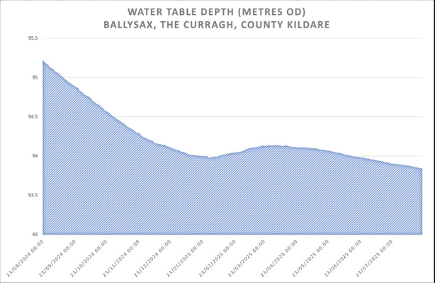
The graph above shows the depth of the water table in the aquifer at Ballysax for the year between August 23rd 2024 and August 22nd 2025 using EPA data. We can see from this graph that the water levels in the aquifer have dropped over the year, and recharge from precipitation over the winter months has been minimal.
Coupled with the drop in precipitation leading to a drop in water levels in streams, rivers, lakes, reservoirs and aquifers is the increase in demand for water during the summer months. As the water stress increases in the environment, we tend to want more water also within our homes and workplaces. In addition to this, water stress tends to be more exaggerated in the east and south east of the country, which coincides with higher populations and more industry.
As a result, we need to conserve as much water as we can. We only have a limited amount of water on the planet, and we are lucky enough in Ireland to have sufficient quantities of it. It is precious and needs to be protected.
Follow RTÉ Brainstorm on WhatsApp and Instagram for more stories and updates
The views expressed here are those of the author and do not represent or reflect the views of RTÉ
 are sinuous ridges of sand and gravel deposited within tunnels carved by great rivers at the edge of the ice sheet during the last glaciation\". Esker Monastery, Esker, Athenry, Co Galway. Photo: Larry Morgan")
