Analysis: Disputes were common and informants often disagreed when the townlands we're familiar with today were created
This article is now available above as a Brainstorm podcast. You can subscribe to the Brainstorm podcast through Apple Podcasts, Stitcher, Spotify or wherever you get your podcasts.
By Catherine Porter, UL and Keith Lilley, QUB
Maps help us to connect with our localities and many of us are familiar with maps of our local area. Historic maps in particular provide us with an important window onto our past and reveal how a place has changed over time. This year marks two centuries since the beginnings of the most detailed historic land survey of Ireland. Led by the British military led Ordnance Survey (OS), and popularised in the 1980s through Brian Friel’s play, 'Translations’, the impacts and traces of the survey on Ireland’s landscape are still seen today.
We often will turn to the first edition Ordnance Survey maps to explore the townlands of our ancestors (perhaps where our families still live today), or to figure out the location of a particular building, well or a stream, or simply explore the complex geographies and histories of the island. The historic outputs of the Ordnance Survey challenge us too in how to reconcile the complex cultural heritage and legacies of the survey with what was the most detailed country-wide large-scale mapping and survey in the world at the time.
The cultural complexities of the OS in Ireland are recorded in a variety of source materials, not just maps. In various archives, museums and repositories across Ireland and Great Britain lie correspondence, statistical accounts, drawings and sketches, and comprehensive lists of place names, providing a pre-famine record of Ireland and its population.
We need your consent to load this rte-player contentWe use rte-player to manage extra content that can set cookies on your device and collect data about your activity. Please review their details and accept them to load the content.Manage Preferences
From RTÉ Radio 1's The History Show, writer Mary Russell tells the story of how the very first Ordnance Survey maps of Ireland – long before GPS - were created
How and why the survey began
In early nineteenth century Ireland, land taxation based on the county cess, and earlier surveys such as the Strafford and Down surveys of the seventeenth century, were deemed an inaccurate reflection of land value. In March 1824, a Select Committee on the Survey and Valuation of Ireland was set up to explore a detailed revaluation of the land. A recommendation by Thomas Colby of the British Ordnance Survey, and later placed in charge of the Irish survey, was to incorporate townlands, and that to do so would require ‘a scale of six inches to one English mile’ (Item 1, Colby’s ‘Instructions for the Interior Survey of Ireland’, 1825).
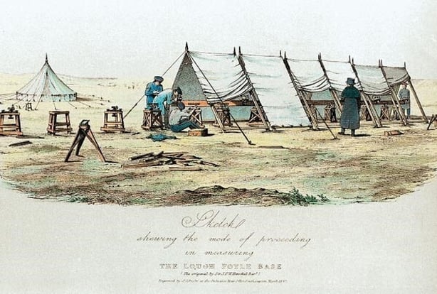
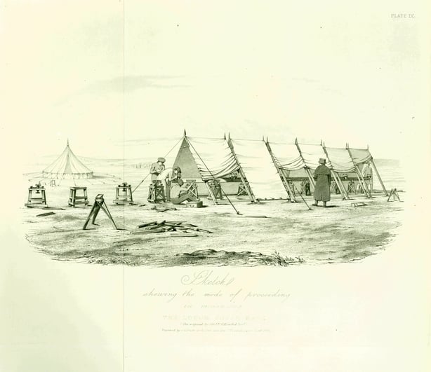
The geographic extent of the survey also required bespoke instruments to deal with the inclement weather and to construct an accurate framework of invisible triangles from the tallest mountain tops to the smallest hills, based on a minutely accurate base line near Lough Foyle (remember your trigonometry from school!), which lies between Derry and Donegal. These same techniques and equipment were later applied to other colonial mapping exercises elsewhere in the world.
Placing boundaries
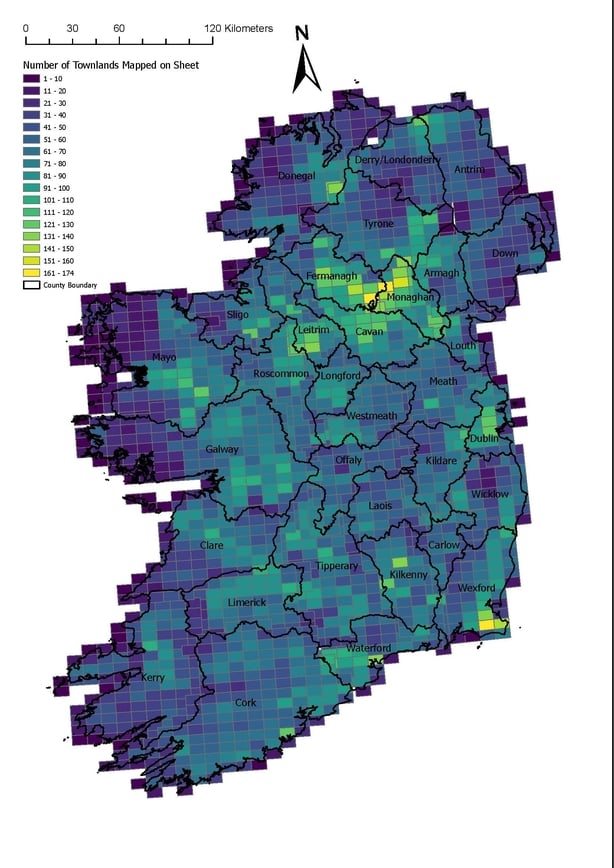
Determining the shape and size of the smallest administrative boundaries in Ireland, the townland, was far from simple. The engineer and civilian, Richard Griffith, led the ‘boundary team’ in setting out the limits and margins for every townland on the island.
As with modern property boundaries, informants often disagreed, and disputes were common. Step by step and with the assistance of local civilians, Griffith and his staff not only marked and defined known townland boundaries, but they also removed reference to the historic land divisions such as the ploughland, tate and ballibo, and created new townlands through a process of addition, amalgamation and splitting of land to form the townlands we are familiar with today.
This process was not without its challenges, local populations playing havoc with the boundary markers, as is witnessed in correspondence between two staff in October 1827:
"Sir… agreeably to your desire I have cautioned my Parishioners against removing or changing the situation of any of the poles put up by the Surveyors, and have also urged them to give every facility to their operations"
(communication from James Brady to Lieutenant Bailey, 22 October, 1827).
Brian Friel brings this to life in his play, Translations:
‘…every time they’d stick one of these poles into the ground and move across the bog, I’d creep up and shift it twenty or thirty paces to the side… Then they’d come back and stare at it and look at their calculations and stare at it again and scratch their heads. And Cripes, d’you know what they ended up doing? They took the bloody machine [the theodolite] apart!’
(Friel, B., Translations, 1980: p11)
Placing names
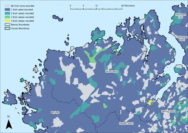
Core to any map are place names, but determining how these would be printed on the final cartography was a complex process. The Topographical Department led by John O’Donovan (Seán Ó Donnabháin) referred to a multitude of written authorities and travelled Ireland collecting and compiling lists of the historical forms to determine the final map presentation of place.
The details recorded by the OS field ‘name books’ are a core source material for today’s linguists and historians in charting the changes to place names and the Irish language across time and geography. Similar to townland boundaries, those authorities consulted differed in opinion and O’Donovan often sought out what he termed ‘the last of the aborigines’ (Irish speakers) to assist him in determining the place names and their histories.
Placing people
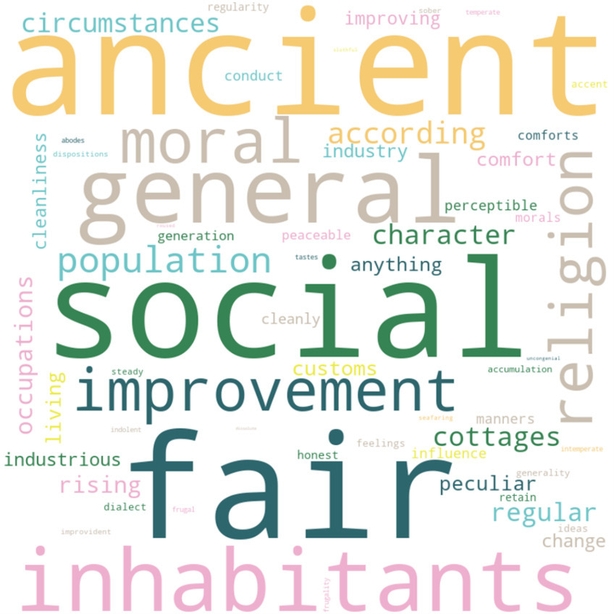
The memoir scheme, originally devised as a supplement to the maps, had military and civilian teams collect and collate details on the landscape, nature, geology, history, infrastructure, people and culture, and make ‘suggestions for improvement’. This important record of pre-famine Ireland unfortunately covers only the north of the island – the scheme was cancelled in 1840 - and shows, in particular, connections between the people and their ancient roots.
It also reveals the bias of some OS staff, especially evident in their ethnographic study of people and culture. Irish homes were frequently described as less clean and the habits of the people less virtuous, inferior, and generally ‘uncivilised’ when compared to the Scottish and English settlers who were remarked on as being industrious, neat and the cause of what was deemed as ‘improvement’ in a parish.
The complex cultural histories and legacies of the OS in Ireland cannot be denied, but nor can the achievement of the venture overall in setting down the bounds and place names for a whole country two centuries ago.
From late June 2024, there will be the opportunity to explore four of the key OS source materials through a free online resource developed by researchers based at the University of Limerick and Queen’s University Belfast through the project, ‘OS200: Digitally Remapping Ireland’s Ordnance Survey Heritage’. More about the project, team and partners can be found at the project website or on social media.
The OS200 project is funded by UKRI-Arts and Humanities Research Council and the Irish Research Council under the ‘UK-Ireland Collaboration in the Digital Humanities Research Grants Call’ (grant numbers AH/W001802/1 and IRC/W001802/1).
Dr Catherine Porter is an Associate Professor of Geography at the University of Limerick. Professor Keith Lilley is a Professor of Historical Geography at Queen’s University Belfast.
Follow RTÉ Brainstorm on WhatsApp and Instagram for more stories and updates
The views expressed here are those of the author and do not represent or reflect the views of RTÉ