
What happened to Ireland's famous Leaving Cert weather in June? It is, you have to say, highly unusual to see people walking around in June decked out in gloves and scarves rather than shorts and sandals. But this is the state of play in Ireland in June 2024 as the country shivers from the chilly conditions and waits for the rain to stop. We spoke to Met Eireann climatologist Paul Moore about what's happening with the weather and if there's any sign of warmer days, a bit of sunshine and some blue skies.
Why is it so cold in June - especially after a warm May?
"Indeed, there’s quite a difference between May and the beginning of June this year. May was our warmest May since records began 125 years ago. During May 2024, a warm and cloudy air mass became established over the country early on. Weak steering currents aloft (a weak jet stream) meant the warmer than normal air mass stuck around for most of the month.
"It was also a relatively cloudy month, and that cloud also prevented the night-time temperatures from dropping much. Those high night-time temperatures were key for ending up with the warmest May on record. While May, of course, is not a particularly warm month usually for Ireland, "warmest" refers to the highest average May temperature.
We need your consent to load this rte-player contentWe use rte-player to manage extra content that can set cookies on your device and collect data about your activity. Please review their details and accept them to load the content.Manage Preferences
From RTÉ Radio 1's Drivetime, meteorologist with Met Eireann Siobhan Ryan on why it's so cold in June (item begins at 1.18)
"June initially was quite dry and warm with high pressure sitting over or just to the west of Ireland. This area of high pressure pulled away further to the west allowing relatively weak weather fronts and a cloudier north-westerly airflow to move in over the country.
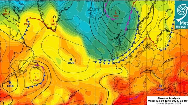
"On June 4th, a cold front moved south, introducing a colder Arctic airmass from the north. While this was happening, low pressure set up over Scandinavia and the high pressure system became anchored to our west, blocking any milder westerly or south-westerly airflows from reaching us.
"Normally, at this time of the year, a cold airmass over us would slowly moderate and warm up. However, with blocking high pressure to the west and low pressure over Scandinavia, further cold fronts moved south over the country on the 8th and 9th, re-enforcing the cold arctic feed from the north."
Are we right in thinking temperatures are below normal for this time of year?
Yes, all June average temperatures are below normal, but not by much. As of June 11th, the differences from the 1981-2010 long term average temperatures (which we use to compare our current climate with the past), range between 0.5 °C below average at Cork Airport, Co Cork to 2.8 °C below average at Markree, Co Sligo. Most of our weather stations are more than 1 °C below average and five of them (out of a total of 25) are more than 2°C below average for June so far. It has also been a very dry June so far, with only 11% of the monthly average rainfall falling up to Tuesday 11th.
How low have temperatures got previously here in June?
The lowest June daily air temperatures occurred at Cloncast, Co Offaly with -3.3 °C on June 1st 1962. In contrast, June 2023 was the warmest June on record with all the primary weather stations finishing between 1.9 °C and 3.9 °C above their June normal temperatures.
But cool weather in early June is not unusual in Ireland: both June 2015 and 2019 were cool. In June 2015, nearly all monthly mean air temperatures were below normal. Parts of the West and North had average temperatures of over 1.0°C below their normal, with the largest difference of 1.4°C below long term average temperatures reported at Markree, Co Sligo.
We need your consent to load this rte-player contentWe use rte-player to manage extra content that can set cookies on your device and collect data about your activity. Please review their details and accept them to load the content.Manage Preferences
From RTÉ Radio 1's Today with Claire Byrne, climate scientist Prof John Sweeney on how the heavier rainfall we've experienced of late in Ireland is due to climate change
The first three weeks of June 2019 were dominated by a blocking high-pressure system over Greenland and a downstream trough over Ireland and the UK. This introduced cool and unsettled weather with low pressure close to or over the country for much of the time, bringing bands of rain or showers in a cyclonic flow. The average temperatures finished between 0.1 °C and 1.0 °C below the normal June values.
What has the jet stream got to do with all of this?
The jet stream was weak during May so once a warm airmass became stablished over Ireland, it was hard to shift. During June so far, the jet stream has been directed around the blocking high pressure in the Atlantic and then southwards from Greenland towards and to the south of Ireland. This has helped feed in further reinforcements of the cold Arctic airmasses from the north, which has kept it cold here.
Can we expect more extreme weather events like the flooding in Spain and Germany and heatwaves in Greece and India?
Unfortunately, global warming continues, and climate projections indicate that extreme weather events will continue to become more extreme and more frequent as global temperatures continue to rise due to human caused climate change. The World Meteorological Organisation published a recent report that says there is an 80% chance that the average global temperature within five years will "temporarily" exceed 1.5 °C above the pre-industrial level. It predicts that the global mean near-surface temperature for each of the next five years will be between 1.1 to 1.9 degrees higher than the average over the years from 1850 to 1900.
The lowest June daily air temperatures occurred at Cloncast, Co Offaly with -3.3 °C on June 1st 1962
The frequency and intensity of extreme events go hand in hand with the increase in global temperatures, so there are higher chances of more prolonged and severe heatwaves and droughts as well as more severe and intense rainfall events.
How long can we expect this cold spell to last? Will we still need the heating on in July?
It has been 10 days since any stations around Ireland experienced air temperatures over 20.0°C. The recent cold feed of Arctic air has now been cut off and Atlantic weather fronts are forecast to break through on Thursday June 13th. This will moderate the temperatures somewhat, bringing them back close to average.
But this will also bring more unsettled conditions with low pressure moving down from the northwest and stalling over Ireland for the coming weekend. This will bring bands of rain or showers form Thursday onwards. We are less than half way through June 2024 so the statistics for June 2024 above will likely change by the end of the month.
Follow RTÉ Brainstorm on WhatsApp and Instagram for more stories and updates
The views expressed here are those of the author and do not represent or reflect the views of RTÉ