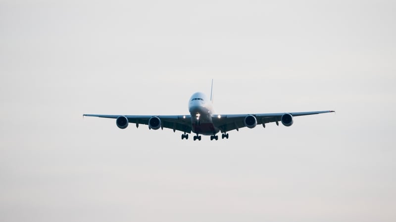
Analysis: From busy skies to climate change, there's the increased chance of an airplane flying through turbulent areas these days
Emergency services are at Dublin Airport to deal with a number of passengers who have been injured on a flight from Doha due to turbulence. Earlier this week, a Singapore Airlines flight hit severe turbulence, with 48 people still being treated in hospitals. The Boeing 777-300ER flight, carrying 211 passengers and 18 crew, diverted to Bangkok for an emergency landing after the plane was buffeted by turbulence that flung passengers and crew around the cabin, with some slamming into the ceiling. Aisling Beatty is Deputy Head of Aviation Forecasting in Met Éireann and we asked her to answer all our questions about turbulence, what causes it and when it's dangerous.
What is turbulence and what causes it?
Turbulence is the irregular motion of air as a result of vertical currents (updrafts and downdrafts) and eddies (a whirl of air). Updrafts and downdrafts are regular features of air movement, but vary in intensity based on a number of factors including air temperature and pressure but also irregular terrain or buildings.
We need your consent to load this rte-player contentWe use rte-player to manage extra content that can set cookies on your device and collect data about your activity. Please review their details and accept them to load the content.Manage Preferences
From RTÉ News, One dead on Singapore Airlines flight after 'severe turbulence'
Areas of turbulence form by several different methods:
- Frontal turbulence occurs in an area where two air masses meet (i.e. a front). The mixing of air causes unstable conditions and when a plane flies through a weather front, it will feel some degree of turbulence. In this type, turbulence will mostly likely be experienced in a cloud layer.
- Clear air turbulence (CAT) occurs where there is no cloud so is much harder to avoid. This type of turbulence happens regularly near or on the edges of jet streams and is felt by airplanes that cross through a fast-moving jet stream into surrounding air that is moving slower.
- Orographic turbulence occurs near the ground as a result of friction between the air and the ground. The intensity of the turbulent eddies depends on the wind strength, the nature of the terrain and the stability of the air. The greater the wind speed, the rougher the terrain and the more unstable the air, the greater the turbulence.
- Convective turbulence occurs when the sun heats the earth's surface unevenly. Different surfaces warm at different rates – rock and sand are heated more rapidly than grassy surfaces, and much more rapidly than water. Convective currents are a result of warm air rising and cooler air descending. Convective currents may be strong enough the produce cumulonimbus (CB) clouds or thunderstorm clouds. Moderate to severe turbulence should always be expected in and near a CB cloud and in some cases, extreme turbulence too.
Experiencing minor turbulence might be fairly common. But how often is turbulence dangerous?
The International Civil Aviation Organisation (ICAO) has defined the effects felt by inside aircraft for each category of turbulence intensity. Moderate turbulence can cause loose objects to move around, passengers will feel strain against their seatbelts and walking will be difficult. Severe turbulence will cause loose objects to be tossed around, a violent strain will be felt against seatbelts and walking around will be impossible.
Meteorological organisations like Met Éireann issue SIGMET warnings for significant meteorological phenomena that might be encountered in-flight within the airspace under their remit (Met Éireann issues them for within Irish airspace). SIGMET warnings indicate the presence or forecast the likelihood of hazards to aviation such as severe turbulence, severe icing, thunderstorms, severe mountain waves and volcanic ash.
We need your consent to load this rte-player contentWe use rte-player to manage extra content that can set cookies on your device and collect data about your activity. Please review their details and accept them to load the content.Manage Preferences
From RTÉ Brainstorm, The science behind the weather forecast with Conor Murphy (Maynooth University), Paul Dunlop (Ulster University) and Conor Sweeney (UCD)
As mentioned, SIGMET warnings highlight areas of forecasted or observed severe turbulence, and pilots will often report and share experiences of turbulence and can identify storm clouds on satellite and RADAR imagery. Generally, pilots use these as well as turbulence projections to plan flight paths and avoid areas of severe turbulence as much as possible. However, severe turbulence can be expected every day across the world so it would be practically impossible to always avoid areas of severe turbulence, especially areas of clear air turbulence (which is cloudless, so not detected by radar for example).
Is climate change making turbulence happen more frequently?
Recent research provides evidence that clear air turbulence (CAT) has increased over the past four decades, consistent with the expected effects of climate change. Additionally, there are more airplanes in the sky these days, so there's the increased chance of an airplane flying through turbulent areas. The increased number of planes also may contribute to turbulence themselves by producing wake vortices from their wings and so the airplane following the same path may experience low or moderate turbulence as a result of the previous airplane.
What actually goes into an aviation forecast?
Turbulence forecasts will include the predicted intensity and both the vertical and horizontal extent of the expected turbulence. Forecast charts may differentiate between areas of expected CAT and areas of convective turbulence. In general, Aviation forecasters periodically issue a number of forecast products:
Terminal Aerodrome Forecast (TAF): This contains weather information for airfields in a concise code format and it includes the wind, prevailing visibility, significant weather, cloud and expected significant changes in the weather
Meteorological Terminal Aviation Routine Weather Report (METAR): This includes data for the temperature, dew point, wind, precipitation, cloud information, visibility and pressure.
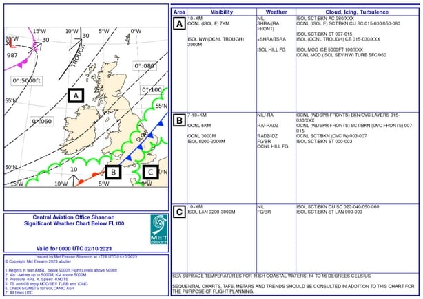
Significant Weather Chart (SIG WX): These graphical products which are created by the Aviation forecaster illustrate the areas of main meteorological concern. The map gives a snapshot of fronts and areas of weather. The chart relates to all weather below 10,000 feet and is divided up into areas. It displays details of visibility, weather, cloud, icing and turbulence.
Significant Meteorological Information (SIGMET): A SIGMET is a weather advisory that contains meteorological information concerning the safety of all aircraft. The advisory can cover events such as thunderstorms, severe turbulence, severe ice, severe mountain waves, and volcanic ash for example.
Daily specialised forecasts for Irish Airports: Met Éireann also provides detailed daily forecasts for some of the airports in Ireland. These specialised forecasts provide more detail as well as a longer time frame for the possibility of icing, snow etc.
Follow RTÉ Brainstorm on WhatsApp and Instagram for more stories and updates
The views expressed here are those of the author and do not represent or reflect the views of RTÉ