

Analysis: there is approximately 1.5 million hectares of peatland in Ireland, but it is difficult to know the actual amount for certain
Peat is a soil that is made up of partially decayed vegetation. It forms in wetland areas where the waterlogged environment slows down the decomposition process. Peat has been used as a fuel source, as well as in horticulture and agriculture. In Ireland, peat has played an important role in the country's history and economy, and will be important for future environmental efforts.
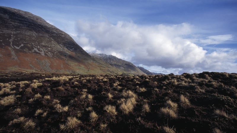
But how much peat is actually in Ireland and how do we go about this finding out? Peat formed in two settings in Ireland. Along the west coast and at about 200+ m above sea level, blanket bogs formed. These are so called as they "blanket" the landscape. These formed as cutting of trees allowed removal of nutrients from the soil by rainwater. Heather and other bog flora took over and bogs started to grow.
The other type of peatland formed in the midlands of Ireland and are known as raised bogs. These started forming about 12,000 years ago. As glaciers retreated, they left depressions in the landscape. These filled with melt and rainwater, which became stagnant and allowed for peat habitats to grow.
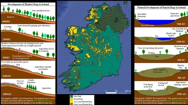
There is approximately 1.5 million hectares of peatland in Ireland, about 21% of the country's total land area, but it is difficult to know the actual amount for certain. This is because peat is not homogeneous. It can vary in thickness, density, and composition depending on the type of vegetation that formed it, the amount of water available, and the length of time it has been decaying. Some peat deposits may be only a few centimetres thick, but others may be several metres deep.
One way to estimate the amount of peat in Ireland is to conduct field surveys, where samples of peat are taken from various locations and analysed. This can give a detailed picture of the composition and properties of the peat, as well as its thickness. However, it is time-consuming and expensive. It's particularly difficult to find the edges of peatlands using field surveys. How can you say that the soil has changed from a peat to a non-peat soil unless you do lots of samples!
Another way to estimate the amount of peat is to measure the area of peatland using satellites. There are two main type of satellite data. The first is optical and the second is radar and this data is provided free to the public via the European Space Agency. The main advantage is that satellites pass overhead regularly so they can be used to look at how peatlands are changing over time too.
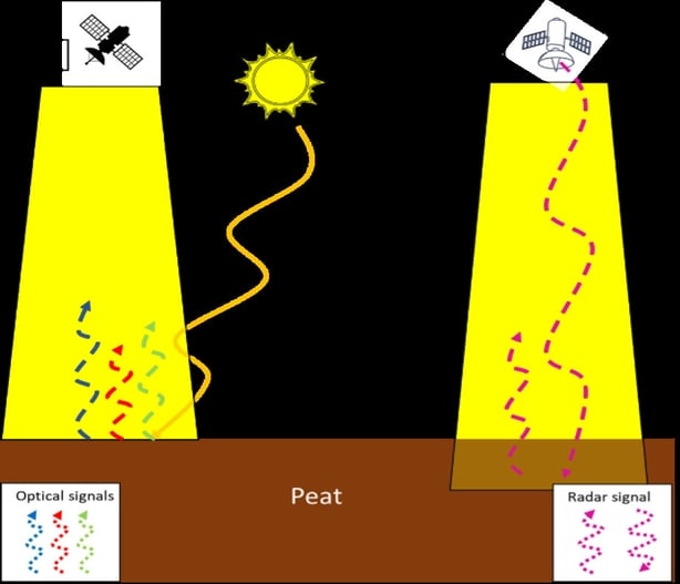
Optical data measures energy from the sun that has reflected off the surface of the earth. This includes energy from visible light, that we can see, to infra-red energy, that we can't, but the satellite can. Different landcover reflect these energies in unique ways and so have a "spectral signature", like a fingerprint. Optical data does have problems when used to map peatland extent because the land can be obscured by cloud cover or vegetation.
Radar data is a measurement of the signal that bounces back after microwave pulses are sent towards the ground, allowing the creation of images of the land surface. This data can overcome the problems faced by optical data when mapping peatland extent as it penetrates clouds and vegetation. However, radar data can be affected by signal noise, which limits the resolution, or the area on the ground, that can give reliable information.
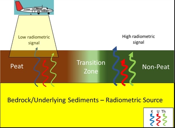
A recent study has attempted to redefine the peatland boundaries in Ireland using Radiometrics. Radiometrics is a measurement of environmental radioactivity and this radioactivity comes from the soil and rocks. Different rocks emit different amount of radiation; however, peat is unique. It doesn't generally emit any radiation, being made of organic material so areas of really low signal are very likely to be peatlands when we look at radiometric data from across the country.
This method has one big advantage over satellite data, because it can see through the ground and tell us about the soil below. This means it can find that elusive "transition zone" where peat soils transition to mineral soil and it can identify peat under things like forest or grass, leading to an accurate understanding of where peatlands are and how much peat there really is!
The Geological Survey, Ireland already has this data available across 80% of the country as part of the Tellus project. Access to this date is giving us the ability to better understand the peatland extent in Ireland in new and innovative ways. Later this year, a Tellus Peatmap will be produced and accessed through the Geological Survey, Irelands online data viewer, and this may help us to discover how much peat is actually in Ireland.
The views expressed here are those of the author and do not represent or reflect the views of RTÉ