


Traces of the Civil War can be found in the bullet holes that mark buildings and even gateposts around the country. But this period has been comparatively ignored by archaeological investigations - until now. Damian Shiels tells how the Battle for Cork left its mark
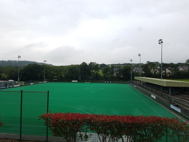
Rochestown's Garryduff Sports Centre seems an unlikely place to encounter traces of the Irish Civil War. At first glance, the immaculately maintained playing pitches and courts seem to mark this out as an entirely modern landscape. Yet on 9 August 1922 this spot was at the epicentre of some of the most ferocious fighting witnessed in the county during the entire revolutionary decade. While today the Garryduff Centre resounds to the clash of hockey sticks and the pop of tennis racquets, a century ago it was the scream of machine-gun fire that pierced the air.
These deadly projectiles were emerging from the field boundaries of Moneygurney townland, rising away to the south – the location of well-positioned anti-Treaty IRA gunners. Their target was men of the National Army. Back then, today’s Sports Centre was the home of Dr James Lynch and his family. Dr Lynch watched the impact of the fire, with bullets
"flying around like driven hail…raising clouds of dust and mortar as they buried themselves in the walls…"
It wasn’t long before they were also striking National Army soldiers. As the Lynches looked on, their home was converted into both a temporary command centre and emergency dressing-station. In the century since the Civil War there have been many changes in Garryduff, and what was once an impressive residence is now an important community Sports Centre.
But despite those changes, many of the walls into which those Civil War bullets buried themselves survive. The house, though altered, still stands, as do some of the original outbuildings. They are but one element of a remarkable Civil War conflict landscape that survives, barely remembered, hidden in plain sight on the fringes of Cork City.
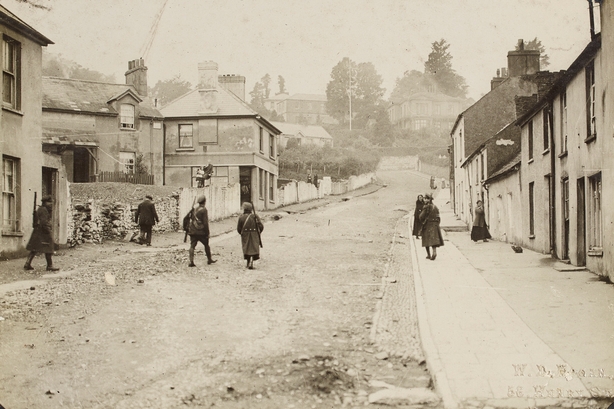
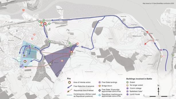
The fighting that engulfed the site of the Garryduff Sports Centre on 9 August 1922 occurred during the second day of the Battle for Cork. The National Army’s effort to wrest control of the city from the Anti-Treaty IRA had begun the previous day, when around 450 troops were put ashore at the docks in Passage West – the main thrust in a series of landings designed to overcome the IRA’s "Munster Republic."
The defenders' efforts to halt the National Army’s advance to Cork led to three days of intense fighting around Passage West, Rochestown and Douglas – by far the largest engagement in Cork during the 1919-23 period. The battle, which ended in National Army victory and the fall of Cork, has been well documented historically – most notably in Dr John Borgonovo’s definitive The Battle for Cork (Mercier Press, 2012).
Yet there are no reminders of it on the ground where it was fought, and—until recently-- no systematic efforts to identify remnants of the battlefield landscape. This is a scenario repeated across the great majority of conflict sites that pepper the island from 1916-23. They are well documented in the pages of history and often well commemorated through historic and modern memorials, but we have very little understanding of what survives of the landscape that bore witness to—and played a role in—the events themselves.
Falling through the cracks
These physical sites of the "decade of revolution" are an important element of our recent archaeological heritage. But they are sites that largely fall outside the current parameters of archaeological study, management and protection, which focuses primarily on medieval and prehistoric monuments and landscapes.
Most of the buildings that played a role in the War of Independence and Civil War also fall through the cracks, absent from local and national inventories that focus primarily on architectural rather than historical merit. The consequence of our lack of study (and resulting lack of knowledge) of these physical traces of revolution makes the appropriate management of this heritage resource extremely challenging. As a result, it is among the most vulnerable of all Ireland’s heritage assets.
But challenges bring opportunities. There is significant potential for local communities to engage with these sites revealing and recording these hidden revolutionary landscapes, directly contributing towards new knowledge, facilitating new forms of engagement with the past, and creating new capacity to manage these fragile landscapes.
The area around the Garryduff Sports Centre and the wider 1922 battlefield offers a striking case in point. They were revealed during a recent pilot study of the archaeological remnants of the Battle for Cork, undertaken by a joint archaeological and historical team with the assistance of the Passage West Maritime Museum. It quickly became apparent that the physical remains of the battlefield landscape are everywhere to be seen.
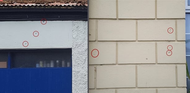
Some of the most dramatic manifestations of the fighting come in Passage West, where bullet-impact scars abound. These indentations in the town’s brick and masonry buildings were created by bullets fired on 8 August 1922, during the initial stages of the fighting. In many instances, we can even say which side fired them.
Bullet holes
On Dock Street, the impacts date to the moments immediately after the National Army landing, as the disembarking troops engaged anti-Treaty IRA defenders overlooking them to the west. Impacts also pock-mark the stone of homes overlooking the Passage West docks, but these were created by IRA bullets, fired from across the river channel on Great Island. A visit to the island itself reveals some of the buildings the IRA occupied, in the form of houses in Carrigaloe that still bear the violent marks of the National Army’s response.
While bullet impact-scars are the most apparent remnant of the battle, they represent just the tip of the iceberg. Scattered throughout Passage West and Rochestown are standing buildings and structures which represented key positions for both sides during the first two days of the battle. Keen-eyed observers enjoying the benches in Rochestown’s Brendan Barry Murphy Park might note differences in the fabric of the attractive old road-bridge beside them. These are the traces of repairs necessitated by the blowing of the bridge by anti-Treaty IRA forces, as they sought to delay the advance of the National Army from Passage West.
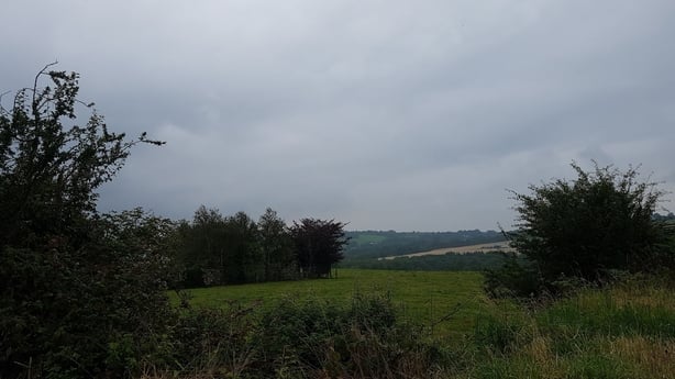
The significance of other structures is revealed through the historical sources, a number of which played an important role in the fighting. But it is perhaps the fields, roads and woods running south of Rochestown that conjure some of the most visceral echoes of the engagement. Some of the deadliest clashes took place around Garryduff Sports Centre, Garryduff Woods, Oldcourt and Moneygurney.
The field boundaries that still stand here are the primary fortifications of the Battle for Cork – used both for shelter and manoeuvre by the National Army as they advanced, and as lines of defence by the anti-Treaty IRA, laying down withering fire from their banks. Armed with the knowledge of their use, it is difficult not to gaze uphill from Garryduff Sports Centre without considering the thoughts of attackers and defenders during those terrible moments in 1922, as they faced conditions that were starkly reminiscent of horrors experienced on the Western Front.
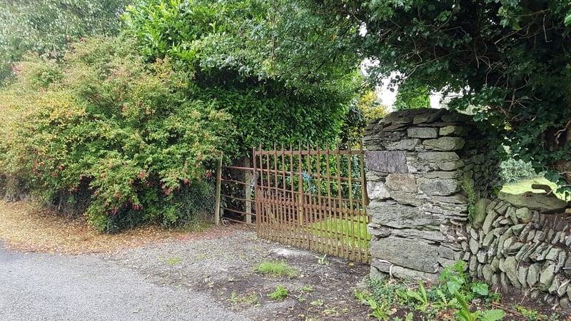
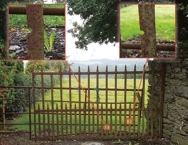
The second day’s fighting in this area reached a crescendo at a place called Cronin’s Cottage – which still stands, though much changed. Located on the high ground in Moneygurney, it was the location of a doomed "last stand" made by some of the IRA defenders. Just a stone’s throw away is what is perhaps the most important survivor of all in the landscape of the Battle for Cork. Known locally as "battlefield gate", it stands on or close to its original 1922 position. Men lost their lives within yards if it, cut down by machine guns at almost point-blank range. The gate, still pierced with bullet-holes, stands in silent testament to the deadly firefight that overtook this quiet lane on 9 August 1922.
The preliminary archaeological analysis undertaken on the Battle for Cork has only scratched the surface of what survives in one of Ireland’s most important Civil War landscapes. But it has demonstrated that attempting to identify, understand and manage these "landscapes of revolution" is well worth the effort, both for present and future generations.
You can find out more about the archaeological potential of revolutionary landscapes by visiting the Landscapes of Revolution Project website at www.landscapesofrevolution.com. Talks from the recent online conference "Material Legacies: The Archaeology of the Irish Revolutionary Period", hosted by the UCD School of Archaeology in association with Abarta Heritage and the Landscapes of Revolution Project, are also freely available to view on the UCD Archaeology YouTube Channel here.
